
Oberägeri topographic map
Interactive map
Click on the map to display elevation.
About this map
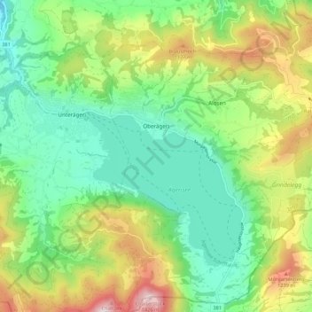
Name: Oberägeri topographic map, elevation, terrain.
Location: Oberägeri, Zoug, 6315, Suisse (47.09200 8.59451 47.16348 8.70116)
Average elevation: 912 m
Minimum elevation: 635 m
Maximum elevation: 1,446 m
Other topographic maps
Click on a map to view its topography, its elevation and its terrain.
Risch-Rotkreuz
Suisse > Zoug > Risch-Rotkreuz
Risch-Rotkreuz, Zoug, 6343, Suisse
Average elevation: 452 m