
Lorze topographic map
Interactive map
Click on the map to display elevation.
About this map
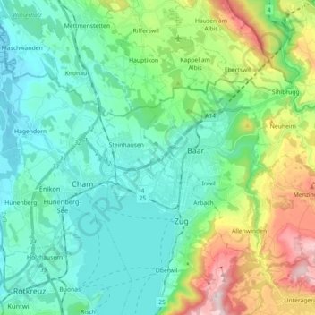
Name: Lorze topographic map, elevation, terrain.
Location: Lorze, Zoug, 6341, Suisse (47.13662 8.41007 47.24838 8.58899)
Average elevation: 541 m
Minimum elevation: 386 m
Maximum elevation: 1,025 m
Other topographic maps
Click on a map to view its topography, its elevation and its terrain.
Risch-Rotkreuz
Suisse > Zoug > Risch-Rotkreuz
Risch-Rotkreuz, Zoug, 6343, Suisse
Average elevation: 452 m