
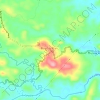
Bagong Silang I topographic map
Interactive map
Click on the map to display elevation.
About this map
Name: Bagong Silang I topographic map, elevation, terrain.
Average elevation: 80 m
Minimum elevation: 28 m
Maximum elevation: 187 m
Other topographic maps
Click on a map to view its topography, its elevation and its terrain.
Aguit-it
Philippines > Camarines Norte > Vinzons
Aguit-it, Vinzons, Camarines Norte, Bicol Region, 4603, Philippines
Average elevation: 5 m
Calasgasan
Philippines > Camarines Norte > Daet
Calasgasan, Daet, Camarines Norte, Bicol Region, 4600, Philippines
Average elevation: 19 m
Santo Domingo
Philippines > Camarines Norte > Vinzons
Santo Domingo, Vinzons, Camarines Norte, Bicol Region, 4603, Philippines
Average elevation: 15 m
Poblacion 1 Barangay Site
Philippines > Camarines Norte > Basud > Bactas
Poblacion 1 Barangay Site, Bactas, Basud, Camarines Norte, Bicol Region, 4600, Philippines
Average elevation: 6 m
Basud
Basud, Camarines Norte, Bicol Region, 4608, Philippines
Average elevation: 14 m
Laniton
Laniton, Camarines Norte, Bicol Region, 4608, Philippines
Average elevation: 19 m
Tanawan
Tanawan, Camarines Norte, Bicol Region, Philippines
Average elevation: 122 m
Quinapaguian
Philippines > Camarines Norte > Mercedes
Quinapaguian, Mercedes, Camarines Norte, Bicol Region, Philippines
Average elevation: 0 m
Guinacutan
Guinacutan, Camarines Norte, Bicol Region, Philippines
Average elevation: 10 m
Sta. Elena
Sta. Elena, Camarines Norte, Bicol Region, 4603, Philippines
Average elevation: 5 m
Mangkasay
Mangkasay, Camarines Norte, Bicol Region, Philippines
Average elevation: 29 m
Palali
Philippines > Camarines Norte > Exciban
Palali, Exciban, Camarines Norte, Bicol Region, Philippines
Average elevation: 113 m
Daet
Philippines > Camarines Norte > Daet
Daet, Camarines Norte, Bicol Region, 4600, Philippines
Average elevation: 9 m
Calaguas Group of Islands
Philippines > Camarines Norte > Vinzons
Calaguas Group of Islands, Vinzons, Camarines Norte, Bicol Region, 4603, Philippines
Average elevation: 1 m
Bibirao
Philippines > Camarines Norte > Daet > Bibirao
Bibirao, Daet, Camarines Norte, Bicol Region, 4600, Philippines
Average elevation: 15 m
Daet
Daet, Camarines Norte, Bicol Region, 4600, Philippines
Average elevation: 6 m
Palanas
Philippines > Camarines Norte > Paracale > Palanas
Palanas, Paracale, Camarines Norte, Bicol Region, 4605, Philippines
Average elevation: 21 m
Poblacion Norte
Philippines > Camarines Norte > Paracale
Poblacion Norte, Paracale, Camarines Norte, Bicol Region, 4605, Philippines
Average elevation: 19 m
Vinzons
Vinzons, Camarines Norte, Bicol Region, 4603, Philippines
Average elevation: 10 m
Bagumbayan
Philippines > Camarines Norte > Paracale > Bagumbayan
Bagumbayan, Paracale, Camarines Norte, Bicol Region, 4605, Philippines
Average elevation: 23 m
Itomang
Philippines > Camarines Norte > Daet > Itomang
Itomang, Daet, Camarines Norte, Bicol Region, 4600, Philippines
Average elevation: 10 m
Capalonga
Capalonga, Camarines Norte, Bicol Region, 4607, Philippines
Average elevation: 13 m
Bicol National Park
Philippines > Camarines Norte > Tuaca
Bicol National Park, Tuaca, Camarines Norte, Bicol Region, Philippines
Average elevation: 123 m
Paracale
Philippines > Camarines Norte > Paracale
Paracale, Camarines Norte, Bicol Region, 4605, Philippines
Average elevation: 20 m
Jose Paganiban
Jose Paganiban, Camarines Norte, Bicol Region, 4606, Philippines
Average elevation: 28 m
Labo
Labo, Camarines Norte, Bicol Region, Philippines
Average elevation: 30 m
Tailon Lighthouse
Tailon Lighthouse, Jose Paganiban, Camarines Norte, Bicol Region, Philippines
Average elevation: 0 m
Paracale
Paracale, Camarines Norte, Bicol Region, 4605, Philippines
Average elevation: 11 m
San Vicente
Philippines > Camarines Norte > San Vicente
San Vicente, Camarines Norte, Bicol Region, 4602, Philippines
Average elevation: 52 m
Talisay
Philippines > Camarines Norte > Talisay
Talisay, Camarines Norte, Bicol Region, 4602, Philippines
Average elevation: 10 m
Barangay I
Philippines > Camarines Norte > Barangay I
Barangay I, Daet, Camarines Norte, Bicol Region, 4600, Philippines
Average elevation: 8 m
Calagua Islands
Calagua Islands, Vinzons, Camarines Norte, Bicol Region, 4603, Philippines
Average elevation: 8 m
Mercedes
Mercedes, Camarines Norte, Bicol Region, 4601, Philippines
Average elevation: 3 m
Bagasbas Beach
Philippines > Camarines Norte > Daet > Bagasbas
Bagasbas Beach, Bagasbas, Daet, Camarines Norte, Bicol Region, 4600, Philippines
Average elevation: 1 m
Lugui
Philippines > Camarines Norte > Lugui
Lugui, Camarines Norte, Bicol Region, Philippines
Average elevation: 271 m
Palumbato Island
Palumbato Island, Camarines Norte, Bicol Region, Philippines
Average elevation: 23 m
Guintinua Island
Guintinua Island, Vinzons, Camarines Norte, Bicol Region, 4603, Philippines
Average elevation: 4 m
Bagasbas
Philippines > Camarines Norte > Daet > Bagasbas
Bagasbas, Daet, Camarines Norte, Bicol Region, 4600, Philippines
Average elevation: 1 m
Cobangbang
Philippines > Camarines Norte > Cobangbang
Cobangbang, Daet, Camarines Norte, Bicol Region, 4600, Philippines
Average elevation: 8 m
Pamorangon
Philippines > Camarines Norte > Pamorangon
Pamorangon, Daet, Camarines Norte, Bicol Region, 4600, Philippines
Average elevation: 9 m
Poblacion Norte
Philippines > Camarines Norte > Poblacion Norte
Poblacion Norte, Paracale, Camarines Norte, Bicol Region, 4605, Philippines
Average elevation: 22 m
Santa Elena
Santa Elena, Camarines Norte, Bicol Region, Philippines
Average elevation: 66 m
Huag Island
Huag Island, Vinzons, Camarines Norte, Bicol Region, 4603, Philippines
Average elevation: 2 m
Canimog Island
Canimog Island, Camarines Norte, Bicol Region, Philippines
Average elevation: 14 m
Bicol Natural Park
Philippines > Camarines Norte > Manlimonsito
Bicol Natural Park, Manlimonsito, Camarines Norte, Bicol Region, Philippines
Average elevation: 197 m
Tanao Islands
Tanao Islands, Camarines Norte, Bicol Region, Philippines
Average elevation: 24 m
Ingalan Island
Ingalan Island, Vinzons, Camarines Norte, Bicol Region, 4603, Philippines
Average elevation: 2 m
Tailon Island
Tailon Island, Camarines Norte, Bicol Region, Philippines
Average elevation: 0 m
Culasi Peak
Culasi Peak, Camarines Norte, Bicol Region, Philippines
Average elevation: 50 m
Palita Island
Palita Island, Camarines Norte, Bicol Region, Philippines
Average elevation: 0 m