
Tanawan topographic map
Click on the map to display elevation.
About this map
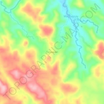
Name: Tanawan topographic map, elevation, terrain.
Location: Tanawan, Camarines Norte, Bicol Region, Philippines (14.19334 122.52405 14.23334 122.56405)
Average elevation: 122 m
Minimum elevation: 31 m
Maximum elevation: 217 m
Other topographic maps
Click on a map to view its topography, its elevation and its terrain.
Daet
Daet is located in the southeastern part of Camarines Norte. It is bounded in the east by the town of Mercedes; in the south by the municipality of Basud; in southwest by San Lorenzo Ruiz town; in the north by Pacific Ocean; in the west by San Vicente and northwest by Talisay. The provincial capital covers a…
Average elevation: 8 m
Bicol Natural Park
Philippines > Camarines Norte > Basud
The Bicol Natural Park spreads across the Camarines Norte municipalities of Basud and Mercedes, and the Camarines Sur municipalities of Sipocot and Lupi. It is situated at an elevation of 536 metres (1,759 ft) above sea level bordered by the Tuaca River to the north, the agricultural lands of Sipocot and Lupi…
Average elevation: 191 m
Daet
Daet is located in the southeastern part of Camarines Norte. It is bounded in the east by the town of Mercedes; in the south by the municipality of Basud; in southwest by San Lorenzo Ruiz town; in the north by Pacific Ocean; in the west by San Vicente and northwest by Talisay. The provincial capital covers a…
Average elevation: 6 m