
Make a donation
Mercer County topographic map
Click on the map to display elevation.
Make a donation
Mercer County
According to the U.S. Census Bureau, the county has a total area of 473 square miles (1,230 km2), of which 462 square miles (1,200 km2) is land and 11 square miles (28 km2) (2.3%) is water. The entire county has an elevation difference of less than 300 feet. The highest point is on the southern county line at 1071 feet above sea level. This is in proximity to the head waters for the Wabash River. The lowest point in the county is 780 feet above sea level. This point is located on the northern county line where the St. Marys River crosses over.
Make a donation
About this map
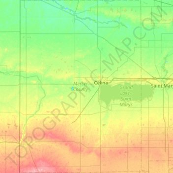
Name: Mercer County topographic map, elevation, terrain.
Location: Mercer County, Ohio, United States (40.35194 -84.80424 40.72815 -84.43171)
Average elevation: 271 m
Minimum elevation: 236 m
Maximum elevation: 336 m
Make a donation
Other topographic maps
Click on a map to view its topography, its elevation and its terrain.
Cuyahoga River
United States > Ohio > Cuyahoga County > Cleveland
The upper Cuyahoga River, starting at 1,093 feet (333 m) over 84 miles (135 km) from its mouth, drops in elevation fairly steeply, creating falls and rapids in some places; the lower Cuyahoga River only drops several feet along the last several miles of the lower river to 571 feet (174 m) at the mouth on Lake…
Average elevation: 196 m
Columbus
United States > Ohio > Franklin County > Columbus
The confluence of the Scioto and Olentangy rivers is just north-west of Downtown Columbus. Several smaller tributaries course through the Columbus metropolitan area, including Alum Creek, Big Walnut Creek, and Darby Creek. Columbus is considered to have relatively flat topography thanks to a large glacier that…
Average elevation: 255 m
Make a donation
Make a donation
Miamisburg Community Park
United States > Ohio > Montgomery County > Miamisburg
Average elevation: 241 m
Make a donation
Make a donation
Make a donation
Make a donation
Etna
United States > Ohio > Licking County
Etna (formerly Carthage) is an unincorporated community and census-designated place (CDP) in Licking County, Ohio, United States. As of the 2020 census it had a population of 1,209. It lies at an elevation of 1,069 feet (326 m) at the intersection of U.S. Route 40 and State Route 310. It was listed as a…
Average elevation: 321 m
Make a donation
Make a donation
Make a donation
Make a donation
Make a donation
Make a donation
Make a donation
Make a donation
Make a donation
Make a donation
Make a donation
Make a donation
Make a donation
Make a donation
Make a donation
Make a donation
Make a donation
Make a donation
Make a donation