
Mount Tabor topographic map
Interactive map
Click on the map to display elevation.
About this map
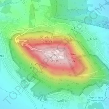
Name: Mount Tabor topographic map, elevation, terrain.
Location: Mount Tabor, Jezreel Subdistrict, North District, Israel (32.68706 35.38957 32.68716 35.38967)
Average elevation: 250 m
Minimum elevation: 101 m
Maximum elevation: 561 m
Other topographic maps
Click on a map to view its topography, its elevation and its terrain.
Shefaram
Shefa-Amr is located in the North District of Israel at the entrance to the Galilee. It is located 13 kilometres (8.1 mi) from the Mediterranean Sea and 20 kilometres (12 mi) from each of three cities, Haifa, Acre and Nazareth, where many of the inhabitants are employed. The city is located on seven hills,…
Average elevation: 125 m
Sea of Galilee
The Sea of Galilee (Hebrew: יָם כִּנֶּרֶת, Judeo-Aramaic: יַמּא דטבריא, גִּנֵּיסַר, Arabic: بحيرة طبريا), also called Lake Tiberias or Kinneret, is a freshwater lake in Israel. It is the lowest freshwater lake on Earth and the second-lowest lake in the world (after…
Average elevation: -67 m
Tiberias
Tiberias is located on the shore of the Sea of Galilee and the western slopes of the Jordan Rift Valley overlooking the lake, in the elevation range of −200 to 200 metres (−660–660 feet). Tiberias has a climate that borders a Hot-summer Mediterranean climate (koppen Csa) and a Hot Semi-arid climate…
Average elevation: -48 m