
Make a donation
Tiberias topographic map
Click on the map to display elevation.
Make a donation
Tiberias
Tiberias is located on the shore of the Sea of Galilee and the western slopes of the Jordan Rift Valley overlooking the lake, in the elevation range of −200 to 200 metres (−660–660 feet). Tiberias has a climate that borders a Hot-summer Mediterranean climate (koppen Csa) and a Hot Semi-arid climate (koppen BSh), with an annual precipitation of about 400 mm (15.75 in). Summers in Tiberias average a maximum temperature of 36 °C (97 °F) and a minimum temperature of 21 °C (70 °F) in July and August. The winters are mild, with temperatures ranging from 8 to 18 °C (46–64 °F). Extremes have ranged from 0 °C (32 °F) to 46 °C (115 °F).
Make a donation
About this map
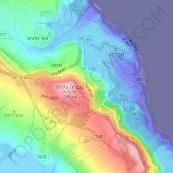
Name: Tiberias topographic map, elevation, terrain.
Average elevation: -48 m
Minimum elevation: -218 m
Maximum elevation: 249 m
Make a donation