
Sea of Galilee topographic map
Interactive map
Click on the map to display elevation.
Sea of Galilee
The Sea of Galilee (Hebrew: יָם כִּנֶּרֶת, Judeo-Aramaic: יַמּא דטבריא, גִּנֵּיסַר, Arabic: بحيرة طبريا), also called Lake Tiberias or Kinneret, is a freshwater lake in Israel. It is the lowest freshwater lake on Earth and the second-lowest lake in the world (after the Dead Sea, a salt lake), with its elevation fluctuating between 215 and 209 metres (705 and 686 ft) below sea level (depending on rainfall). It is approximately 53 km (33 mi) in circumference, about 21 km (13 mi) long, and 13 km (8.1 mi) wide. Its area is 166.7 km2 (64.4 sq mi) at its fullest, and its maximum depth is approximately 43 metres (141 ft). The lake is fed partly by underground springs, but its main source is the Jordan River, which flows through it from north to south with the outflow controlled by the Degania Dam.
About this map
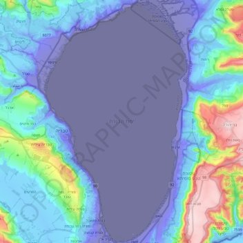
Name: Sea of Galilee topographic map, elevation, terrain.
Location: Sea of Galilee, Kinneret Subdistrict, North District, Israel (32.70551 35.51622 32.89644 35.64978)
Average elevation: -67 m
Minimum elevation: -219 m
Maximum elevation: 369 m
Other topographic maps
Click on a map to view its topography, its elevation and its terrain.