
Make a donation
Tian Shan topographic map
Click on the map to display elevation.
Make a donation
Tian Shan
The Torugart Pass, at 3,752 metres (12,310 ft), marks the border between Kyrgyzstan and Xinjiang. The lower-altitude, forested Alatau ranges in the northern Tian Shan is home to Turkic-speaking pastoral tribes.
Make a donation
About this map
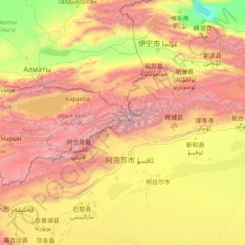
Name: Tian Shan topographic map, elevation, terrain.
Location: Tian Shan, China (41.32734 76.33299 42.60164 85.12205)
Average elevation: 1,689 m
Minimum elevation: 193 m
Maximum elevation: 7,035 m
Make a donation
Other topographic maps
Click on a map to view its topography, its elevation and its terrain.
Hong Kong
Hong Kong has a humid subtropical climate (Köppen Cwa), characteristic of southern China, despite being located south of the Tropic of Cancer. Summer is hot and humid, with occasional showers and thunderstorms and warm air from the southwest. Typhoons occur most often then, sometimes resulting in floods or…
Average elevation: 47 m
Shanghai
The golden age of Shanghai began with its elevation to municipality after it was separated from Jiangsu on 7 July 1927. This new Chinese municipality covered an area of 494.69 km2 (191.0 sq mi), including the modern-day districts of Baoshan, Yangpu, Zhabei, Nanshi, and Pudong, but excluded the foreign…
Average elevation: 12 m
Make a donation
Chongqing
The central urban area of Chongqing, or Chongqing proper, is a city of unique features. Built on mountains and partially surrounded by the Yangtze and Jialing rivers, it is known as a "mountain city" and a "city on rivers". The night scene of the city is very illuminated, with millions of lights and their…
Average elevation: 318 m
Hong Kong
Hong Kong has a humid subtropical climate (Köppen Cwa), characteristic of southern China, despite being located south of the Tropic of Cancer. Summer is hot and humid, with occasional showers and thunderstorms and warm air from the southwest. Typhoons occur most often then, sometimes resulting in floods or…
Average elevation: 47 m
Make a donation
Beijing
Beijing is situated at the northern tip of the roughly triangular North China Plain, which opens to the south and east of the city. Mountains to the north, northwest and west shield the city and northern China's agricultural heartland from the encroaching desert steppes. The northwestern part of the…
Average elevation: 460 m
Sichuan
Due to great differences in terrain, the climate of the province is highly variable. In general, it has strong monsoonal influences, with rainfall heavily concentrated in the summer. Under the Köppen climate classification, the Sichuan Basin (including Chengdu) in the eastern half of the province experiences…
Average elevation: 2,522 m
Make a donation
Xi'an
China > Shaanxi > Weiyang District > Xi'an
Xi'an lies on the Guanzhong Plain in the south-central part of Shaanxi province, on a flood plain created by the eight surrounding rivers and streams. The city has an average elevation of 400 metres (1,312 ft) above sea level and an annual precipitation of 553 mm (21.8 in). The urban area of Xi'an is located…
Average elevation: 412 m
Make a donation
Beijing
Beijing is situated at the northern tip of the roughly triangular North China Plain, which opens to the south and east of the city. Mountains to the north, northwest and west shield the city and northern China's agricultural heartland from the encroaching desert steppes. The northwestern part of the…
Average elevation: 455 m
Make a donation
Make a donation
Make a donation
Xinjiang
A semiarid or desert climate (Köppen BSk or BWk, respectively) prevails in Xinjiang. The entire region has great seasonal differences in temperature with cold winters. The Turpan Depression recorded the hottest temperatures nationwide in summer, with air temperatures easily exceeding 40 °C (104 °F). Winter…
Average elevation: 2,188 m
Shanghai
The golden age of Shanghai began with its elevation to municipality on 7 July 1927. This new Chinese municipality covered an area of 494.69 km2 (191.0 sq mi), including the modern-day districts of Baoshan, Yangpu, Zhabei, Nanshi, and Pudong, but excluded the foreign concessions territories. Headed by a Chinese…
Average elevation: 5 m
Make a donation
Chongqing
The central urban area of Chongqing, or Chongqing proper, is a city of unique features. Built on mountains and partially surrounded by the Yangtze and Jialing rivers, it is known as a "mountain city" and a "city on rivers". The night scene of the city is very illuminated, with millions of lights and their…
Average elevation: 754 m
Yunnan
Yunnan is situated in a mountainous area, with high elevations in the northwest and low elevations in the southeast. Most of the population lives in the eastern part of the province. In the west, the altitude can vary from the mountain peaks to river valleys by as much as 3,000 m (9,800 ft). Yunnan is rich in…
Average elevation: 1,713 m
Make a donation
Shanghai
The golden age of Shanghai began with its elevation to municipality after it was separated from Jiangsu on 7 July 1927. This new Chinese municipality covered an area of 494.69 km2 (191.0 sq mi), including the modern-day districts of Baoshan, Yangpu, Zhabei, Nanshi, and Pudong, but excluded the foreign…
Average elevation: 12 m
Mount Kailash
China > Tibet > Purang County > Darchen
Mount Kailash (also Kailasa; Kangrinboqê or Gang Rinpoche; Tibetan: གངས་རིན་པོ་ཆེ; simplified Chinese: 冈仁波齐峰; traditional Chinese: 岡仁波齊峰; Sanskrit: कैलास, IAST: Kailāsa), is a mountain in the Ngari Prefecture, Tibet Autonomous Region of China. It has an…
Average elevation: 5,756 m
Make a donation
Make a donation
Beijing
Beijing is situated at the northern edge of the roughly triangular North China Plain, which opens to the south and east of the city. Mountains to the north, northwest and west shield the city and northern China's agricultural heartland from the encroaching desert steppes. The northwestern part of the…
Average elevation: 460 m
Kangding
Kangding has a monsoon-influenced climate, lying in the transition between a humid continental (Dwb) and a subtropical highland climate (Cwb) on the Köppen system. Despite the elevation of 2,560 metres (8,400 ft), the diurnal temperature variation averages at most 10.6 °C (19.1 °F) in any month. From April…
Average elevation: 3,331 m
Make a donation
Make a donation
Make a donation
Hong Kong
Hong Kong has a humid subtropical climate (Köppen Cwa), characteristic of southern China, despite being located south of the Tropic of Cancer. Summers are long, hot and humid, with occasional showers and thunderstorms and warm air from the southwest. The humid nature of Hong Kong exacerbates the warmth of…
Average elevation: 47 m
Nagqu City
Nagqu is located in the northeast of Tibet. Nagqu Town is 330 kilometres (210 mi) by the China National Highway 109 northeast of Lhasa. Nagqu is bordered by Bayingolin and Hotan Prefectures of Xinjiang to the north, Haixi, Yushu Prefectures of Qinghai and Chamdo to the east, Nyingchi, Lhasa and Shigatse to the…
Average elevation: 4,864 m
Make a donation
Ürümqi
The largest city in western China, Ürümqi has earned a place in the Guinness Book of Records as the most remote city from any sea in the world. It is about 2,500 kilometres (1,600 mi) from the nearest coastline as Ürümqi is the closest major city to the Eurasian pole of inaccessibility, although Karamay…
Average elevation: 1,294 m
K2
China > Xinjiang > Cenling County
K2 is nicknamed "The King of Mountains" and "The Mountaineers' Mountain", as well as "The Mountain of Mountains", a phrase popularized by Italian climber Reinhold Messner in his book on K2. Although the summit of Everest is at a higher altitude, K2 is a more difficult and dangerous climb. This is in part due…
Average elevation: 7,482 m
Make a donation
Make a donation
Barköl Kazakh Autonomous County
Barkol Kazakh Autonomous County spans a total area of 38,400 square kilometres (14,800 mi2), including 25,500 square kilometres (9,800 mi2) of mountains and the Gobi Desert, accounting for 66% of the total area of the autonomous county. The terrain is high in the southeast and low in the northwest, with an…
Average elevation: 1,436 m
Make a donation
Make a donation
Mount Makalu
China > Tibet > Tingri County
Makalu (Nepali: मकालु हिमाल, romanized: Makālu himāl; Chinese: 马卡鲁峰; pinyin: Mǎkǎlǔ Fēng) is the fifth-highest mountain on Earth, with a summit at an elevation of 8,485 metres (27,838 ft) AMSL. It is located in the Mahalangur Himalayas 19 km (12 mi) southeast of Mount Everest,…
Average elevation: 7,479 m
Make a donation
Make a donation
Kunming
Kunming (/kʊnˈmɪŋ/;[3] Chinese: 昆明; pinyin: Kūnmíng), also known as Yunnan-Fu, is the capital and largest city of Yunnan province, China.[4] It is the political, economic, communications and cultural centre of the province as well as the seat of the provincial government. The headquarters of many of…
Average elevation: 1,463 m
Make a donation
Shangri-La
Shangri-La has either a dry-winter, warm-summer humid continental climate (Köppen climate classification: Dwb) using the 0 °C (32 °F) isotherm, or a dry-winter subtropical highland climate (Köppen climate classification: Cwb) using the −3 °C (26.6 °F) isotherm, both of which are unusually cool by…
Average elevation: 3,342 m
Make a donation
Make a donation
Yunnan
Yunnan is situated in a mountainous area, with high elevations in the northwest and low elevations in the southeast. Most of the population lives in the eastern part of the province. In the west, the altitude can vary from the mountain peaks to river valleys by as much as 3,000 m (9,800 ft). Yunnan is rich in…
Average elevation: 1,713 m
Jiuzhaigou
China > Sichuan > Jiuzhaigou County
The county consists of nine villages in a valley in Sichuan Province. The main ethnic group in the county is Han, with the second being Tibetan. The county seat has an altitude of about 1,400 m (4,600 ft).[1] It has a total area of 2,041 square miles (5,286 km2).[2] As of 2015, the county's total population…
Average elevation: 2,520 m
Fujian
The province is mostly mountainous and is traditionally said to be "eight parts mountain, one part water, and one part farmland" (八山一水一分田). The northwest is higher in altitude, with the Wuyi Mountains forming the border between Fujian and Jiangxi. It is the most forested provincial-level…
Average elevation: 302 m
Make a donation