
Make a donation
Barköl Kazakh Autonomous County topographic map
Click on the map to display elevation.
Make a donation
Barköl Kazakh Autonomous County
Barkol Kazakh Autonomous County spans a total area of 38,400 square kilometres (14,800 mi2), including 25,500 square kilometres (9,800 mi2) of mountains and the Gobi Desert, accounting for 66% of the total area of the autonomous county. The terrain is high in the southeast and low in the northwest, with an average elevation of 1,650 metres (5,410 ft). In the south is Mount Barkol, in the middle is Mount Moqinura, and in the north is Mount Beita. Barkol Mountain is located on the southern edge of the county and is the eastern section of the Tianshan Mountains. It stretches for more than 160 kilometres (99 mi) within the county, with an average elevation of 3,300 metres (10,800 ft). The peaks above 3,600 metres (11,800 ft) above sea level are covered with snow all year round and there are a large number of glaciers. The central part of Barkol Kazakh Autonomous County is the Moqin Wula Mountain, a branch of the Tianshan Mountains. The Moqin Wula Mountain extends from the northwest to the southeast. The northernmost part is the Beita Mountain, part of the Altai Mountains, which belongs to the Eastern Junggar fault block mountain system. There are 1.34 million mu of wetlands. The woodland is 1.227 million mu, the forest coverage rate is 1.45%, and there are more than 500 kinds of wild plants. Wild animals in the autonomous county include red deer, snow leopards, wild asses, Mongolian gazelles, wild boar, wolves, Corsac foxes, pine martens, marmots, snow chickens, quails, eagles, and falcons.
Make a donation
About this map
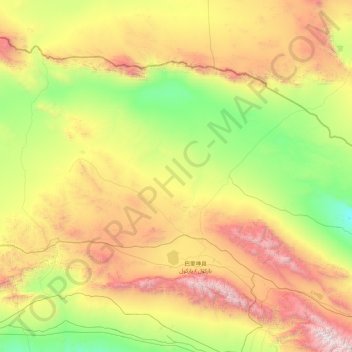
Name: Barköl Kazakh Autonomous County topographic map, elevation, terrain.
Location: Barköl Kazakh Autonomous County, Hami, Xinjiang, China (43.37093 91.28447 45.09890 94.76596)
Average elevation: 1,436 m
Minimum elevation: 294 m
Maximum elevation: 4,682 m
Make a donation
Other topographic maps
Click on a map to view its topography, its elevation and its terrain.