
Make a donation
Roosevelt County topographic map
Click on the map to display elevation.
Make a donation
About this map
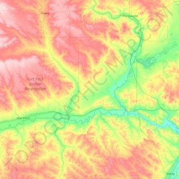
Name: Roosevelt County topographic map, elevation, terrain.
Location: Roosevelt County, Montana, United States (48.00050 -105.84400 48.56394 -104.04415)
Average elevation: 703 m
Minimum elevation: 569 m
Maximum elevation: 911 m
Make a donation
Other topographic maps
Click on a map to view its topography, its elevation and its terrain.
Make a donation
Bancroft Pond Nature Area
United States > Montana > Missoula County > Missoula
Average elevation: 1,005 m
Make a donation
Make a donation
Make a donation
Bozeman
United States > Montana > Gallatin County > Bozeman
Bozeman is located at an elevation of 4,820 feet (1,470 m). The Bridger Mountains are to the north-northeast, the Tobacco Root Mountains to the west-south-west, the Big Belt Mountains and Horseshoe Hills to the northwest, the Hyalite Peaks of the northern Gallatin Range to the south and the Spanish Peaks of…
Average elevation: 1,679 m
Make a donation
Make a donation
Make a donation