
Make a donation
Jalisco topographic map
Click on the map to display elevation.
Make a donation
Jalisco
Jalisco is made up of a diverse terrain that includes forests, beaches, plains, and lakes. Altitudes in the state vary from 0 to 4,300 meters (0 to 14,110 ft) above sea level, from the coast to the top of the Nevado de Colima. The Jalisco area contains all five of Mexico's natural ecosystems: arid and semi arid scrublands, tropical evergreen forests, tropical deciduous and thorn forests, grasslands and mesquite grasslands, and temperate forests with oaks, pines and firs. Over 52% of the bird species found in Mexico live in the state, with 525, 40% of Mexico's mammals with 173 and 18% of its reptile species. There are also 7,500 species of veined plants. One reason for its biodiversity is that it lies in the transition area between the temperate north and tropical south. It also lies at the northern edge of the Sierra Madre del Sur and is on the Trans-Mexican Volcanic Belt, which provides a wide variety of ecological conditions from tropical rainforest conditions to semi arid areas to areas apt for conifer forests.
Make a donation
About this map
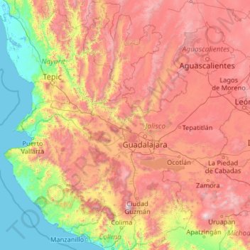
Name: Jalisco topographic map, elevation, terrain.
Location: Jalisco, Mexico (18.92587 -105.69540 22.75025 -101.51054)
Average elevation: 1,301 m
Minimum elevation: -2 m
Maximum elevation: 4,016 m
Make a donation
Other topographic maps
Click on a map to view its topography, its elevation and its terrain.
Make a donation
Villahermosa
Villahermosa is located in the southeast of Mexico between the rivers Grijalva and Carrizal. The average elevation of the city is 10 meters above sea level. The city also has several lagoons, the largest and most important of them being La Laguna de las Ilusiones (Illusions Lagoon).
Average elevation: 9 m
Make a donation
Acapulco
Mexico > Guerrero > Acapulco de Juárez
The city, located on the Pacific coast of Mexico in the state of Guerrero, is classified as one of the state's seven regions, dividing the rest of the Guerrero coast into the Costa Grande and the Costa Chica. Forty percent of the municipality is mountainous terrain; another forty percent is semi-flat; and the…
Average elevation: 99 m
Ciudad Juárez
Due to its location in the Chihuahuan Desert and high altitude, Ciudad Juárez has a cold desert climate (Köppen: BWk). Seasons are distinct, with hot summers, mild springs and autumns, and cold winters. Summer average high is 35 °C (95 °F) with lows of 21 °C (70 °F). Winter highs average 14 °C (57 °F)…
Average elevation: 1,228 m
Make a donation
Make a donation
Make a donation
Make a donation