
Zentral-Departement topographic map
Interactive map
Click on the map to display elevation.
About this map
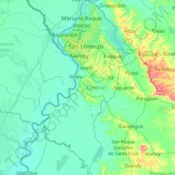
Name: Zentral-Departement topographic map, elevation, terrain.
Location: Zentral-Departement, Región Oriental, Paraguay (-26.02512 -57.82741 -25.09579 -57.18151)
Average elevation: 98 m
Minimum elevation: 47 m
Maximum elevation: 559 m
Other topographic maps
Click on a map to view its topography, its elevation and its terrain.
Departamento de Presidente Hayes
Departamento de Presidente Hayes, Presidente Hayes, Región Occidental, Paraguay
Average elevation: 140 m
Departamento de Canindeyú
Departamento de Canindeyú, Canindeyú, Región Oriental, Paraguay
Average elevation: 293 m
Brunnental
Brunnental, Teniente 1° Manuel Irala Fernández, Presidente Hayes, Región Occidental, Paraguay
Average elevation: 121 m
Villarrica
Paraguay > Guairá > Villarrica
Villarrica, Guairá, Región Oriental, 5000, Paraguay
Average elevation: 160 m
Rio Paraná
Rio Paraná, Misiones, Región Oriental, 6410, Paraguay
Average elevation: 255 m
Ciudad de Corpus Christi
Paraguay > Canindeyú > Ciudad de Corpus Christi
Ciudad de Corpus Christi, Corpus Christi, Canindeyú, Región Oriental, Paraguay
Average elevation: 412 m