
Dakhlet Nouadhibou topographic map
Interactive map
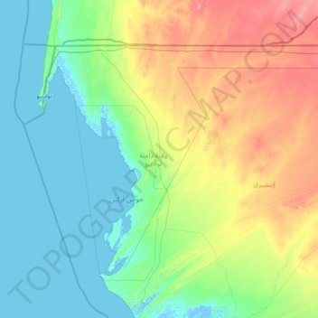
Click on the map to display elevation.
About this map
Name: Dakhlet Nouadhibou topographic map, elevation, terrain.
Location: Dakhlet Nouadhibou, Mauritania (19.39689 -17.06808 21.34174 -14.17319)
Average elevation: 55 m
Minimum elevation: -5 m
Maximum elevation: 293 m
The region is named after the Dakhlet Nouadhibou Bay and contains Mauritania's part of the Cabo Blanco peninsula. It is the westernmost region of the country. It borders Western Sahara to the north, the Mauritanian region of Inchiri to the east and the Atlantic Ocean to the west. The Bay of Arguin dominates the west of the region, the Banc d'Arguin National Park dominates the south and includes much of the bay's islands, the southernmost of the bay and the southeasternmost parts of the park are not in the region, about a third of the region is a national park area. Nearly all of the country's islands and islets lies in this region and they include Echakcher, Kiaones, Niroumi, Nair, Arel, Tidra, the country's largest island, Kijji, Touffat, Cheddid and sometimes Serenni. Mauritania is mostly covered with desert, with only its western regions around the coast of Atlantic Ocean having some vegetation, along with the southern regions on the Senegal river. There are some oasis in the desert regions. Since it is a desert, there are large shifting dunes forming temporary ranges. The average elevation is around 460 m (1,510 ft) above the mean sea level. The rainfall in the northern regions closer to the Tropic of Cancer receives around 100 mm (3.9 in) of annual rainfall compared to the southern portions that receives around 660 mm (26 in). The average temperature is 37.8 °C (100.0 °F), while during the night it reaches 0 °C (32 °F). Due to the geography, the inhabitants historically, have been nomadic. In modern times, people have migrated to urban centres during the drought in 1970 and 1980. There are a few sedentary cultivators, who are located only in the Southern regions of the country. Research has indicated that the Saharan movement has resulted in reduction of rains in the region from the 1960s, when it received close to 250 mm (9.8 in) of rainfall.
Other topographic maps
Click on a map to view its topography, its elevation and its terrain.