
Make a donation
Ticao Island topographic map
Click on the map to display elevation.
Make a donation
About this map
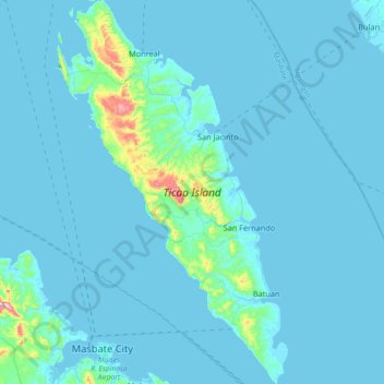
Name: Ticao Island topographic map, elevation, terrain.
Location: Ticao Island, Masbate, Bicol Region, 5417, Philippines (12.33834 123.57895 12.69393 123.80052)
Average elevation: 23 m
Minimum elevation: -1 m
Maximum elevation: 411 m
Make a donation
Other topographic maps
Click on a map to view its topography, its elevation and its terrain.
Make a donation
Make a donation
Make a donation
Make a donation
Cawayan
The locals of Cawayan still largely depend on subsistence farming despite its topographic advantage to adapt commercial farming. The lack of funding for agriculture and infrastructure and its political insecurity due to the presence and activities of armed groups kept by political families and other subversive…
Average elevation: 12 m
Make a donation
Make a donation
Make a donation
Make a donation
Make a donation
Jintotolo Island
Philippines > Masbate > Jintotolo
Its elevation was recorded at around 120 feet (37 m) in 1919. A lighthouse with a tower at 51 feet (16 m) in height exists on Jintotolo island.
Average elevation: 6 m
Make a donation
Make a donation