Geolocate

Philippines topographic map

Click on the map to display elevation.

Philippines

The Philippines is an archipelago of approximately 7,641 islands, with a total land area of about 300,000 square kilometers. The terrain is predominantly mountainous, with narrow coastal plains and valleys. The highest peak is Mount Apo on Mindanao, reaching 2,954 meters (9,692 feet) above sea level. Other notable mountains include Mount Pulag in Luzon and Mount Dulang-Dulang in Mindanao. The Sierra Madre mountain range, the longest in the Philippines, stretches along the eastern side of Luzon. The country is also home to several active volcanoes, such as Mayon, Taal, and Canlaon, contributing to its varied topography. The extensive coastline, measuring 36,289 kilometers (22,549 miles), features numerous bays, coves, and inlets, with Manila Bay being one of the finest harbors in East Asia. The Philippines' diverse landscape includes fertile plains like the Central Luzon plains, known as the "Rice Bowl of the Philippines," and the Cagayan Valley, which is the country's longest river system. The varied terrain has led to a rich biodiversity, with tropical rainforests providing habitats for numerous species. The country's location along the Pacific Ring of Fire makes it prone to earthquakes and volcanic activity, further shaping its dynamic landscape.

About this map

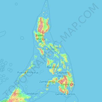
Name: Philippines topographic map, elevation, terrain.

Location: Philippines (4.38333 114.10037 21.32193 126.80308)

Average elevation: 33 m

Minimum elevation: -1 m

Maximum elevation: 2,639 m

Other topographic maps

Click on a map to view its topography, its elevation and its terrain.

Quezon City

Philippines

Founded as a pueblo by Saint Pedro Bautista in 1590, San Francisco del Monte may be considered Quezon City's oldest district. The original land area of the old town of San Francisco del Monte was approximately2.5 square kilometres (1.0 sq mi) and covered parts of what is currently known as Project 7 and 8 and…

Average elevation: 57 m

Cebu City

Philippines > Cebu > Cebu City

Average elevation: 140 m

Boise

United States of America > Idaho > Boise

Boise (/ˈbɔɪsi/ (listen)) is the capital and most populous city of the U.S. state of Idaho, and is the county seat of Ada County. Located on the Boise River in southwestern Idaho, it is 41 miles (66 km) east of the Oregon border, and 110 miles (177 km) north of the Nevada border. The downtown area's…

Average elevation: 1,040 m

Daraga

Philippines > Albay

67.3% of the total municipal land area has a predominantly low elevation of up to 100 metres (330 ft). The surface terrain is generally characterized by combination of level to nearly level areas, gentle to undulating areas and undulating to rolling areas.

Average elevation: 76 m

Sorsogon City

Philippines > Sorsogon

Sorsogon City covers a land area of 31,292 hectares (120.82 sq mi). It is at the southernmost tip of the Bicol Peninsula and of Luzon Island. The city is bounded by Castilla in the west, Manito in the northwest, Albay Gulf in the north, Prieto Diaz in the east, Gubat in the southeast, Casiguran in the…

Average elevation: 89 m

San Fernando

Philippines > Pampanga

Average elevation: 24 m

Cabanatuan

Philippines > Nueva Ecija

Average elevation: 47 m

Peak111

China > Sichuan > Kangding

Average elevation: 5,763 m

Jinyin Hill

China > Guangdong > Guangzhou City

Average elevation: 8 m

Mt.Tai

China > Sichuan > Kangding

Average elevation: 5,585 m

中山东峰

China > Sichuan > Luding County

Average elevation: 5,675 m

泥巴山

China > Sichuan > Kangding

Average elevation: 3,068 m

独海子山

China > Sichuan > Kangding

Average elevation: 4,847 m

Mt. Pan Pan

China > Sichuan > Kangding

Average elevation: 4,600 m

子梅山

China > Sichuan > Kangding

Average elevation: 4,448 m

Polloc

Philippines > Maguindanao del Norte > Parang

Average elevation: 3 m

Caloocan

Philippines > Caloocan > Caloocan

Average elevation: 19 m

Montalban

Philippines > Rizal > Rodriguez

Rodriguez is generally very rough in topography, with 83% of its total land area composed of upland areas, hills and mountain ranges. The remaining 17% low-lying terrain and rolling lands are found at the south-western portion of the municipality, along with the northern portions of the Municipality of San…

Average elevation: 99 m

Baguio

Philippines

In 1903, Filipinos, Japanese and Chinese workers were hired to build Kennon Road, the first road directly connecting Baguio with the lowlands of La Union and Pangasinan. Before this, the only road to Benguet was Naguilian Road, and it was largely a horse trail at higher elevations. Camp John Hay was…

Average elevation: 881 m

多龙果

China > Sichuan > Luding County

Average elevation: 5,155 m

红石峰

China > Sichuan > Luding County

Average elevation: 5,198 m

红石西峰

China > Sichuan > Luding County

Average elevation: 5,167 m

鹊巴北峰

China > Sichuan > Kangding

Average elevation: 5,233 m

鹊巴

China > Sichuan > Luding County

Average elevation: 5,234 m

梅尔西峰

China > Sichuan > Kangding

Average elevation: 5,348 m

日乌且南卫一峰

China > Sichuan > Luding County

Average elevation: 5,627 m

日乌且南卫二峰

China > Sichuan > Luding County

Average elevation: 5,469 m

Neddles

China > Sichuan > Luding County

Average elevation: 5,431 m

Concepcion

Philippines > Quezon > Lopez

Average elevation: 32 m

色曲隆巴

China > Sichuan > Kangding

Average elevation: 5,217 m

塞塞拉

China > Tibet > Kampa County

Average elevation: 5,384 m

Peak46

China > Sichuan > Luding County

Average elevation: 5,238 m

Daddomain

China > Sichuan > Kangding

Average elevation: 5,609 m

达多漫因西卫峰

China > Sichuan > Kangding

Average elevation: 5,569 m

Reddomain

China > Sichuan > Kangding

Average elevation: 5,352 m

Longemain

China > Sichuan > Kangding

Average elevation: 5,647 m

Peak87

China > Sichuan > Luding County

Average elevation: 5,503 m

三连山

China > Heilongjiang > Dongning City > Dongning

Average elevation: 465 m

朱山

China > Shandong > Yantai

Average elevation: 72 m

戴山

China > Jiangsu > Nanjing City

Average elevation: 51 m

中山南峰

China > Sichuan > Luding County

Average elevation: 5,948 m

白海子山北卫峰

China > Sichuan > Kangding

Average elevation: 5,204 m

蛇海子南卫峰

China > Sichuan > Kangding

Average elevation: 4,973 m

笔架山三屏峰

China > Sichuan > Kangding

Average elevation: 5,190 m

Beacon Hill

China > Hong Kong

Average elevation: 153 m

Bijia Shan

China > Sichuan > Kangding

Average elevation: 5,155 m

Bijiashanbeifeng

Taiwan > New Taipei

Average elevation: 349 m

笔架山北峰

China > Sichuan > Kangding

Average elevation: 5,059 m

龙华山

China > Fujian > Longyan City

Average elevation: 878 m

龙华山

China > Sichuan > Luding County

Average elevation: 3,716 m

封山梁子

China > Sichuan > Kangding

Average elevation: 3,731 m

隐海子山

China > Sichuan > Kangding

Average elevation: 4,767 m

Mt.Siao-p'i

China > Sichuan > Kangding

Average elevation: 4,887 m

Mt.Sherap

China > Sichuan > Kangding

Average elevation: 4,810 m

贡康桑日

China > Sichuan > Kangding

Average elevation: 4,799 m

日达曼垭口

China > Sichuan > Kangding

Average elevation: 4,807 m

Nyambo Konka

China > Sichuan > Kangding

Average elevation: 5,521 m

贡巴冰川

China > Sichuan > Kangding

Average elevation: 5,375 m

Vercorin

Switzerland > Wallis > Sierre

Average elevation: 1,120 m

Zinal

Switzerland > Wallis > Sierre > Anniviers

Average elevation: 2,209 m

Mount Malindig

Philippines > Marinduque > Torrijos

Average elevation: 773 m

Samal Island

Philippines > Davao del Norte > Samal

Average elevation: 117 m

Los Angeles

United States > California

Average elevation: 621 m

Tayabas

Philippines > Quezon

Average elevation: 246 m

Mandaue

Philippines

It is one of the two (the other one being the municipality of Consolacion) local government units located within the mainland Metro Cebu where the elevation of land is less than 100 m (330 ft).

Average elevation: 109 m

Indang

Philippines > Cavite > Indang

The topography of Indang is characterised by gently sloping or rolling terrain. Almost 40.36% of its total land area is within the slope grade of 3-8%, while 2,135 hectares is within the slope range of 8-15% which is characterised by undulating or sloping terrain.

Average elevation: 298 m

Tanay

Philippines > Rizal

Average elevation: 32 m

San Pablo

Philippines > Laguna > San Pablo

Average elevation: 220 m

Tagaytay

Philippines > Cavite

The southern and eastern portions of Tagaytay are covered by hills and mountains which is generally forests, pine trees and open grasslands. The city lies along Tagaytay Ridge, a ridge stretching about 32 kilometres (20 mi) from Mount Batulao in the west to Mount Sungay in the east with elevations averaging…

Average elevation: 229 m

Tagum

Philippines > Davao del Norte

One of the significant accomplishments of the officialdom of Tagum during the 1990s was its elevation from a second to the first-class municipality. This opened a gateway to increase its financial resources through the Internal Revenue Allocation (IRA) from the national government and local revenues. This was…

Average elevation: 103 m

Lapu-Lapu

Philippines

Average elevation: 93 m

Dagupan

Philippines > Pangasinan

Average elevation: 12 m

Malolos

Philippines > Bulacan

Malolos is relatively flat of about 0.81% to a gently sloping of 2.17%. The slope of the land descends towards west, southwest to southern direction. The highest land elevation is at about 6.0 meters above sea level while the lowest is only half a meter below sea level. A network of natural waterways and…

Average elevation: 6 m

Bacolod

Philippines

Bacólod (English: Bacolod), is derived from bakólod (Old Spelling: bacólod), the Old Hiligaynon (Old Ilonggo) (Old Spelling: Ylongo and Ilongo) word for a "hill, turtle, mound, rise, hillock, down, any small eminence or elevation", since the resettlement was founded on a stony, hilly area, now the barangay…

Average elevation: 49 m

Antipolo

Philippines > Rizal

Its higher elevation than that of Metro Manila affords it a scenic view of the metropolis, especially at night. Its locally grown mangoes and cashews are popular among tourists, as well as suman – a local delicacy made out of glutinous rice. The Hinulugang Taktak National Park, which was once a popular…

Average elevation: 125 m

Mandaluyong

Philippines

Another claims that the Spaniards named the place based on the report of a navigator named Acapulco, who saw the rolling hills frequently being lashed at by daluyong (“big waves from the sea”). This seems to confirm traditional pre-Hispanic stories that giant waves from the sea would meet the adjoining…

Average elevation: 33 m

San Jose

Philippines > Pampanga > Santa Ana

Average elevation: 6 m

Lapulabao

Philippines > Davao del Sur > Hagonoy

Average elevation: 35 m

Magsaysay

Philippines > Dinagat Islands

Average elevation: 27 m

Remus

Philippines > Cagayan > Baggao

Average elevation: 47 m

Benito Soliven

Philippines > Isabela

Average elevation: 78 m

Tabina

Philippines > Zamboanga del Sur

Average elevation: 53 m

Libmanan

Philippines > Camarines Sur

Average elevation: 6 m

Laguindingan

Philippines > Misamis Oriental

Average elevation: 71 m

Adribe

Libya > Tripoli > Tripoli

Average elevation: 21 m

Balilihan

Philippines > Bohol

Average elevation: 100 m

Valencia

Philippines > Negros Oriental > Valencia

Valencia occupies an area of 14,749 hectares (36,450 acres), 35% of which are classified as plains. The town is 65% mountainous, with elevation averaging from 200 to 500 metres (660 to 1,640 ft) above sea level, with the top of Mount Talinis at an elevation of 1,903 metres (6,243 ft) along the municipal…

Average elevation: 250 m

Legazpi

Philippines > Albay

Legazpi's topography is generally plain on the northeastern areas, with slopes ranging from five to fifteen degrees. The southern areas have mostly rolling to hilly terrain. In the city's coastal areas, the terrain varies from plain (north) to hilly (south). Legazpi is criss-crossed by several rivers including…

Average elevation: 150 m

Bacoor

Philippines > Cavite

Average elevation: 18 m

San Fernando

Philippines > La Union

Average elevation: 81 m

Valencia

Philippines > Bukidnon

The city's topography is characterized as flat to undulating hills with extensive plateaus and mountainous areas and cliffs on both eastern and western portions bounding the municipality of San Fernando on the east and the municipality of Talakag on the west. Its highest point is Mount Kalatungan in the…

Average elevation: 566 m

Ilagan

Philippines > Isabela

Abuan River is the main river of the Northern Sierra Madre Natural Park. It has an average elevation of 82 meters above sea level, and feeds the Abuan watershed in the city. Tourists and visitors can explore the diverse animal and plant life in one of the country’s remaining lush virgin forests. On January…

Average elevation: 123 m

San Juan

Philippines

"San Juan" is a contraction of the city's traditional name of "San Juan del Monte" (lit. 'Saint John of the Mountain'). As with numerous other places in the Philippines, the name combines a patron saint and a toponym; in this case Saint John the Baptist with the locale's hilly terrain and relatively higher…

Average elevation: 35 m

Pasay

Philippines

Average elevation: 14 m

Vigan

Philippines > Ilocos Sur

Vigan is situated in a Quaternary Age sedimentary plain called the Vigan-Bantay Plain which is part of the Ilocos coastal plain. The Vigan-Bantay Plain is bounded on the east by a moderately rugged Miocene sediments consisting of interbedded sandstones and shale to very rugged Meta-volcanics and Meta sediment…

Average elevation: 63 m

Butuan

Philippines

Average elevation: 115 m