
Calamba topographic map
Interactive map
Click on the map to display elevation.
About this map
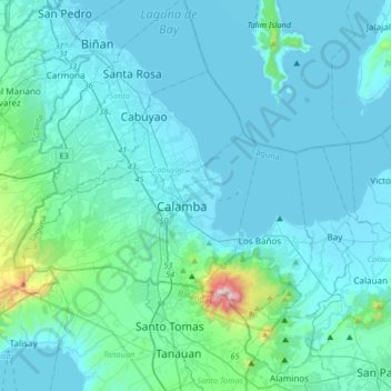
Name: Calamba topographic map, elevation, terrain.
Location: Calamba, Laguna, Calabarzon, 4027, Philippines (14.04602 120.99565 14.36602 121.31565)
Average elevation: 100 m
Minimum elevation: -3 m
Maximum elevation: 1,073 m
Other topographic maps
Click on a map to view its topography, its elevation and its terrain.
Laguna de Bay
Laguna de Bay (Spanish for "Lagoon/Lake of Bay"; Tagalog: Lawa ng Bay, [baɪ]), also known as Laguna Lake, is the largest lake in the Philippines. It is located southeast of Metro Manila, between the provinces of Laguna to the south and Rizal to the north. A freshwater lake, it has a surface area of 911–949…
Average elevation: 62 m
Pangil
The municipality is strategically situated at the southern tip of Sierra Madre mountain range (six barangays) and along the eastern margin of Jalajala Peninsula and just west of the northwestern shore of the easternmost major embayment of Laguna de Bay (two barangays). Its narrow strip of territory traverses…
Average elevation: 165 m
Luisiana
Locals call the town Little Baguio of Laguna because of its high elevation and cool climate like the City of Baguio.
Average elevation: 300 m
Mounts Banahaw–San Cristobal Protected Landscape
Philippines > Laguna > Nagcarlan
Average elevation: 707 m
Bumbungan River
Philippines > Laguna > Cavinti
The waterfalls for which the Bumbungan river is famous is the Magdapio Falls, a section of the river in the town of Cavinti where the river drops about 300 feet (91 m). Because the original boat ride to reach the falls starts in Pagsanjan, it became known as the Pagsanjan Falls. This round trip boat ride…
Average elevation: 260 m
Majayjay
Majayjay is a geographically landlocked area situated in the southernmost part of Laguna. It nestles at the foot of Mt. Banahaw, and due to its higher altitude at some 2,700+ ft above sea level, the town makes for a popular vacation destination during summer in the Philippines. It was once branded as the…
Average elevation: 488 m
Majayjay
Majayjay is a geographically landlocked area situated in the southernmost part of the province of Laguna. It nestles at the foot of Mt. Banahaw, and due to its higher altitude at some 2,700+ ft above sea level, the town makes for a popular vacation destination during summer in the Philippines. It was once…
Average elevation: 488 m
Luisiana
Locals call the town Little Amigos Dísmo because of its high elevation and cool climate like the City of Baguio.
Average elevation: 300 m