
Make a donation
Metro Manila topographic map
Click on the map to display elevation.
Make a donation
Metro Manila
The Coastal Margin or Lowland is a flat and low plain that faces Manila Bay. Located here is Manila, Navotas, parts of Malabon, and the western part and reclaimed areas of Pasay and Parañaque, where the ground elevation ranges from zero meters on Manila Bay to five meters at the west side of the cities of Mandaluyong and Makati. The Coastal Lowland possesses resources for offshore fisheries and fishpond development, and various reclamation projects in the area are meant for mixed-use urban development.
Make a donation
About this map
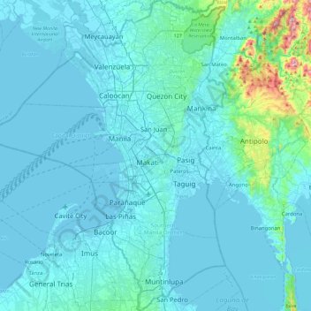
Name: Metro Manila topographic map, elevation, terrain.
Location: Metro Manila, Philippines (14.34726 120.79170 14.78534 121.13502)
Average elevation: 43 m
Minimum elevation: -3 m
Maximum elevation: 587 m
Make a donation
Other topographic maps
Click on a map to view its topography, its elevation and its terrain.
Baguio
In 1903, Filipinos, Japanese and Chinese workers were hired to build Kennon Road, the first road directly connecting Baguio with the lowlands of La Union and Pangasinan. Before this, the only road to Benguet was Naguilian Road, and it was largely a horse trail at higher elevations. Camp John Hay was…
Average elevation: 881 m
Make a donation
Make a donation
Valencia
The city's topography is characterized as flat to undulating hills with extensive plateaus and mountainous areas and cliffs on both eastern and western portions bounding the municipality of San Fernando on the east and the municipality of Talakag on the west. Its highest point is Mount Kalatungan in the…
Average elevation: 566 m
Sorsogon City
Sorsogon City covers a land area of 31,292 hectares (120.82 sq mi). It is at the southernmost tip of the Bicol Peninsula and of Luzon Island. The city is bounded by Castilla in the west, Manito in the northwest, Albay Gulf in the north, Prieto Diaz in the east, Gubat in the southeast, Casiguran in the…
Average elevation: 89 m
Make a donation
Legazpi
Legazpi's topography is generally plain on the northeastern areas, with slopes ranging from five to fifteen degrees. The southern areas have mostly rolling to hilly terrain. In the city's coastal areas, the terrain varies from plain (north) to hilly (south). Legazpi is criss-crossed by several rivers including…
Average elevation: 150 m
Tagaytay
The southern and eastern portions of Tagaytay are covered by hills and mountains which is generally forests, pine trees and open grasslands. The city lies along Tagaytay Ridge, a ridge stretching about 32 kilometres (20 mi) from Mount Batulao in the west to Mount Sungay in the east with elevations averaging…
Average elevation: 229 m
Make a donation
Mandaue
It is one of the two (the other one being the municipality of Consolacion) local government units located within the mainland Metro Cebu where the elevation of land is less than 100 m (330 ft).
Average elevation: 109 m
Make a donation
Make a donation
Valenzuela
The highest elevation point is 38 meters (125 ft) above sea level. Having a surface gradient of 0.55% and a gentle slope, hilly landscape is located in the industrial section of the city in Canumay. The average elevation point is 2 meters (6.6 ft) above sea level.
Average elevation: 24 m
Make a donation
Make a donation
Quezon City
Founded as a pueblo by Saint Pedro Bautista in 1590, San Francisco del Monte may be considered Quezon City's oldest district. The original land area of the old town of San Francisco del Monte was approximately2.5 square kilometres (1.0 sq mi) and covered parts of what is currently known as Project 7 and 8 and…
Average elevation: 57 m
Bantay
It has an average elevation of 100 meters (328.08 feet), with a land area of 7,660 hectares (18,900 acres). It is an elevated and hilly municipality but some barangays, especially those near creeks, are prone to flooding during heavy typhoons.
Average elevation: 8 m
Make a donation
Muñoz
Muñoz is situated 30 kilometres (19 mi) from Cabanatuan, 44 kilometres (27 mi) from Palayan, and 146 kilometres (91 mi) north of the capital Manila. Due to its rich topography and tropical climate, it is now home to agricultural research and technology centers, committed to the production of information and…
Average elevation: 86 m
Make a donation
Baco
Philippines > Oriental Mindoro
Majority of the barangays of the municipality are in lowland areas or below 500 meters above sea level (MASL) and cover 41.88 percent of the total land area (13,035.58 ha). The three largest barangays, which cover most of the forestland, have an elevation that ranges from 500-1,000 and greater than 1,000…
Average elevation: 14 m
Make a donation
Make a donation
Make a donation
Indang
Philippines > Cavite > Indang
The topography of Indang is characterised by gently sloping or rolling terrain. Almost 40.36% of its total land area is within the slope grade of 3-8%, while 2,135 hectares is within the slope range of 8-15% which is characterised by undulating or sloping terrain.
Average elevation: 298 m
Make a donation
Vigan
Vigan is situated in a Quaternary Age sedimentary plain called the Vigan-Bantay Plain which is part of the Ilocos coastal plain. The Vigan-Bantay Plain is bounded on the east by a moderately rugged Miocene sediments consisting of interbedded sandstones and shale to very rugged Meta-volcanics and Meta sediment…
Average elevation: 63 m
Make a donation
Make a donation
San Juan
"San Juan" is a contraction of the city's traditional name of "San Juan del Monte" (lit. 'Saint John of the Mountain'). As with numerous other places in the Philippines, the name combines a patron saint and a toponym; in this case Saint John the Baptist with the locale's hilly terrain and relatively higher…
Average elevation: 35 m
Make a donation
Make a donation
Make a donation
Make a donation
Make a donation
Make a donation
Make a donation
Make a donation
Make a donation