
Thank you for supporting this site ❤️
Make a donation
Make a donation
Dominorog topographic map
Click on the map to display elevation.
Thank you for supporting this site ❤️
Make a donation
Make a donation
About this map
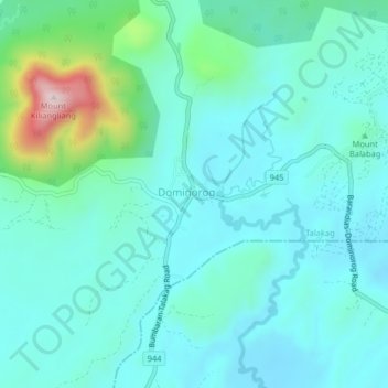
Name: Dominorog topographic map, elevation, terrain.
Location: Dominorog, Talakag, Bukidnon, Northern Mindanao, Philippines (7.89083 124.62807 7.93083 124.66807)
Average elevation: 1,194 m
Minimum elevation: 1,114 m
Maximum elevation: 1,560 m
Thank you for supporting this site ❤️
Make a donation
Make a donation
Other topographic maps
Click on a map to view its topography, its elevation and its terrain.