
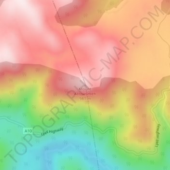
Mount Arrowsmith topographic map
Interactive map
Click on the map to display elevation.
About this map
Name: Mount Arrowsmith topographic map, elevation, terrain.
Location: Mount Arrowsmith, Tasmania, Australia (-42.21053 146.07518 -42.21043 146.07528)
Average elevation: 761 m
Minimum elevation: 459 m
Maximum elevation: 982 m
Other topographic maps
Click on a map to view its topography, its elevation and its terrain.
Launceston
Launceston, City of Launceston, Tasmania, Australia
Average elevation: 194 m
Queenstown
Queenstown, West Coast, Tasmania, 7467, Australia
Average elevation: 330 m
Campbell Town
Australia > Tasmania > Campbell Town
Campbell Town, Northern Midlands, Tasmania, 7210, Australia
Average elevation: 345 m
Clarence Point
Australia > Tasmania > Clarence Point
Clarence Point, West Tamar, Tasmania, Australia
Average elevation: 13 m
Legana
Australia > Tasmania > Launceston > Legana
Legana, Launceston, West Tamar, Tasmania, Australia
Average elevation: 82 m
Mount Nelson
Mount Nelson, Hobart, City of Hobart, Tasmania, Australia
Average elevation: 198 m