Geolocate

Angat Dam topographic map

Interactive map

Click on the map to display elevation.

About this map

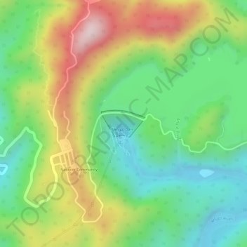
Name: Angat Dam topographic map, elevation, terrain.

Location: Angat Dam, Bulacan, Central Luzon, Philippines (14.90713 121.15786 14.91006 121.16281)

Average elevation: 254 m

Minimum elevation: 87 m

Maximum elevation: 484 m

Other topographic maps

Click on a map to view its topography, its elevation and its terrain.

Malamig

Philippines > Bulacan > Bustos

Average elevation: 20 m

Gatbuca

Philippines > Bulacan > Calumpit

Average elevation: 5 m

San Jose del Monte

Philippines > Bulacan

The elevation of the city ranges from approximately 40 to 900 meters (130 to 2,950 ft) above sea level; the relief transitions from warm lowland to cool upland as one goes eastward. This is because the city is part of the Sierra Madre mountain range. Plains and river valley flats characterize the western and…

Average elevation: 73 m

San Roque

Philippines > Bulacan > Pandi

Average elevation: 26 m

Malolos

Philippines > Bulacan

Malolos is relatively flat of about 0.81% to a gently sloping of 2.17%. The slope of the land descends towards west, southwest to southern direction. The highest land elevation is at about 6.0 meters above sea level while the lowest is only half a meter below sea level. A network of natural waterways and…

Average elevation: 6 m

Calumpit

Philippines > Bulacan > Calumpit

Average elevation: 4 m

Anilao

Philippines > Bulacan > Malolos

Average elevation: 4 m

Malolos

Philippines > Bulacan

Malolos is relatively flat of about 0.81% to a gently sloping of 2.17%. The slope of the land descends towards west, southwest to southern direction. The highest land elevation is at about 6.0 m (19.7 ft) above sea level while the lowest is only 0.5 m (1 ft 8 in) below sea level. A network of natural waterways…

Average elevation: 4 m

Meycauayan

Philippines > Bulacan

Average elevation: 27 m

San Juan

Philippines > Bulacan > Hagonoy

Average elevation: 3 m

Hangga

Philippines > Bulacan > Hagonoy

Average elevation: 3 m

Santa Cruz

Philippines > Bulacan

Average elevation: 3 m

Palapat

Philippines > Bulacan > Hagonoy

Average elevation: 3 m

Manggahan

Philippines > Bulacan > Santa Maria

Average elevation: 24 m

Corazon

Philippines > Bulacan > Calumpit

Average elevation: 5 m

Calumpang

Philippines > Bulacan > Calumpit

Average elevation: 5 m

Iba O'Este

Philippines > Bulacan > Calumpit

Average elevation: 4 m

San Ildefonso

Philippines > Bulacan

Average elevation: 22 m

Gugo

Philippines > Bulacan > Calumpit

Average elevation: 4 m

Sulucan

Philippines > Bulacan > Angat

Average elevation: 34 m

Sibul

Philippines > Bulacan > San Miguel

Average elevation: 59 m

Santa Maria

Philippines > Bulacan

The topography of Santa Maria is generally flat, however, it is becoming hilly towards the north. This area covers the barangays of Silangan, Mag-asawang Sapa, Pulong Buhangin and some parts of Balasing with landscape ranging from 8 to 18 percent slope. The rest of the barangays have a slope range from level…

Average elevation: 24 m

Santa Lucia

Philippines > Bulacan > Calumpit

Average elevation: 3 m

Marilao

Philippines > Bulacan > Marilao

Average elevation: 7 m

Sapang Dayap

Philippines > Bulacan > San Ildefonso

Average elevation: 59 m

San Agustin

Philippines > Bulacan > San Rafael

Average elevation: 17 m

Sergio Bayan

Philippines > Bulacan > Calumpit

Average elevation: 5 m

San Ildefonso

Philippines > Bulacan

Average elevation: 22 m

Mercado

Philippines > Bulacan > Hagonoy

Average elevation: 3 m

Pugad

Philippines > Bulacan > Hagonoy

Average elevation: 2 m

Kaybanban

Philippines > Bulacan > San Jose del Monte

Average elevation: 127 m

San Pascual

Philippines > Bulacan > Hagonoy

Average elevation: 3 m

San Jose del Monte

Philippines > Bulacan

The elevation of the city ranges from approximately 40 to 900 meters (130 to 2,950 ft) above sea level; the relief transitions from warm lowland to cool upland as one goes eastward. This is because the city is part of the Sierra Madre mountain range. Plains and river valley flats characterize the western and…

Average elevation: 73 m

Cambio

Philippines > Bulacan > San Miguel

Average elevation: 17 m

San Miguel

Philippines > Bulacan

Average elevation: 36 m

Buliran

Philippines > Bulacan > San Miguel

Average elevation: 25 m

San Sebastian

Philippines > Bulacan > Hagonoy

Average elevation: 3 m

Bunsuran Ⅲ

Philippines > Bulacan > Pandi

Average elevation: 13 m

Norzagaray

Philippines > Bulacan

Average elevation: 119 m

Balagtas

Philippines > Bulacan

Average elevation: 7 m

Mount Oriod

Philippines > Bulacan > Norzagaray

Average elevation: 873 m

Sumapang Matanda

Philippines > Bulacan > Malolos

Average elevation: 5 m

Angat

Philippines > Bulacan

Average elevation: 61 m

San Rafael

Philippines > Bulacan

Average elevation: 32 m

Santa Maria

Philippines > Bulacan

The topography of Santa Maria is generally flat, however, it is becoming hilly towards the north. This area covers the barangays of Silangan, Mag-asawang Sapa, Pulong Buhangin and some parts of Balasing with landscape ranging from 8 to 18 percent slope. The rest of the barangays have a slope range from level…

Average elevation: 24 m

Malolos

Philippines > Bulacan

Malolos is relatively flat of about 0.81% to a gently sloping of 2.17%. The slope of the land descends towards west, southwest to southern direction. The highest land elevation is at about 6.0 m (19.7 ft) above sea level while the lowest is only 0.5 m (1 ft 8 in) below sea level. A network of natural waterways…

Average elevation: 4 m

Sumapang Matanda

Philippines > Bulacan > Malolos

Average elevation: 5 m

San Roque

Philippines > Bulacan > San Jose del Monte

Average elevation: 140 m

Purok 3

Philippines > Bulacan > San Rafael > Sampaloc

Average elevation: 19 m

Angat River

Philippines > Bulacan

Average elevation: 139 m

San Jose

Philippines > Bulacan > Calumpit

Average elevation: 3 m

Santa Maria

Philippines > Bulacan

The topography of Santa Maria is generally flat, however, it is becoming hilly towards the north. This area covers the barangays of Silangan, Mag-asawang Sapa, Pulong Buhangin and some parts of Balasing with landscape ranging from 8 to 18 percent slope. The rest of the barangays have a slope range from level…

Average elevation: 24 m

Lambakin

Philippines > Bulacan > San Miguel

Average elevation: 39 m

Pandi

Philippines > Bulacan

Pandi is rich in many natural brooks coming from the mainland itself. In some remote areas the lands are still covered by bamboo trees that naturally thrive and multiplies. Some lands privately owned have mango plantations. In some areas that are privately owned are rock deposits being used for housing…

Average elevation: 27 m

Norzagaray

Philippines > Bulacan

Average elevation: 119 m

Balayong

Philippines > Bulacan > Malolos

Average elevation: 4 m

Santa Maria

Philippines > Bulacan

The topography of Santa Maria is generally flat, however, it is becoming hilly towards the north. This area covers the barangays of Silangan, Mag-asawang Sapa, Pulong Buhangin and some parts of Balasing with landscape ranging from 8 to 18 percent slope. The rest of the barangays have a slope range from level…

Average elevation: 24 m

Angat Dam View Deck

Philippines > Bulacan > Norzagaray

Average elevation: 230 m

Bagumbayan

Philippines > Bulacan > Bulakan

Average elevation: 4 m

Santol

Philippines > Bulacan > Balagtas

Average elevation: 8 m

Tibig

Philippines > Bulacan > Bulakan

Average elevation: 4 m

Ciudad de Victoria

Philippines > Bulacan > Bocaue

Average elevation: 11 m

Paradise III

Philippines > Bulacan > San Jose del Monte

Average elevation: 163 m

Hinukay

Philippines > Bulacan > Baliwag

Average elevation: 11 m

Pandi

Philippines > Bulacan

Pandi is rich in many natural brooks coming from the mainland itself. In some remote areas the lands are still covered by bamboo trees that naturally thrive and multiplies. Some lands privately owned have mango plantations. In some areas that are privately owned are rock deposits being used for housing…

Average elevation: 30 m

Diliman I

Philippines > Bulacan > San Rafael

Average elevation: 25 m

San Sebastian

Philippines > Bulacan

Average elevation: 3 m

Santo Niño

Philippines > Bulacan > Calumpit

Average elevation: 5 m

Balubad

Philippines > Bulacan > Bulakan

Average elevation: 4 m

Santiago

Philippines > Bulacan > Malolos

Average elevation: 4 m

Manggahan

Philippines > Bulacan > Santa Maria

Average elevation: 24 m

Coral na Bato

Philippines > Bulacan > San Rafael

Average elevation: 42 m

Binacod

Philippines > Bulacan

Average elevation: 3 m

Iba

Philippines > Bulacan > Hagonoy

Average elevation: 3 m

Binuangan

Philippines > Bulacan > Obando

Average elevation: 2 m

Taliptip

Philippines > Bulacan > Bulakan

Average elevation: 3 m

Maysantol

Philippines > Bulacan > Bulakan

Average elevation: 4 m

Plaridel

Philippines > Bulacan

Average elevation: 9 m

Hagonoy

Philippines > Bulacan > Hagonoy

Average elevation: 3 m

Norzagaray

Philippines > Bulacan

Average elevation: 119 m

Bocaue

Philippines > Bulacan

Average elevation: 7 m

Malolos

Philippines > Bulacan

Malolos is relatively flat of about 0.81% to a gently sloping of 2.17%. The slope of the land descends towards west, southwest to southern direction. The highest land elevation is at about 6.0 m (19.7 ft) above sea level while the lowest is only 0.5 m (1 ft 8 in) below sea level. A network of natural waterways…

Average elevation: 4 m

Lalangan

Philippines > Bulacan > Plaridel

Average elevation: 9 m

Manggahan

Philippines > Bulacan > Santa Maria

Average elevation: 24 m

Malipangpang

Philippines > Bulacan > San Ildefonso

Average elevation: 17 m

Bocaue

Philippines > Bulacan

Average elevation: 7 m

Pulong Yantok

Philippines > Bulacan > Santa Maria

Average elevation: 67 m

San Mateo

Philippines > Bulacan > Norzagaray

Average elevation: 199 m

Calumpit

Philippines > Bulacan

Average elevation: 4 m

Tibagan

Philippines > Bulacan > San Miguel

Average elevation: 28 m

San Ildefonso

Philippines > Bulacan

Average elevation: 22 m

Pio Cruzcosa

Philippines > Bulacan > Calumpit

Average elevation: 4 m

Mambog

Philippines > Bulacan > Malolos

Average elevation: 4 m

Sapang Pahalang

Philippines > Bulacan > San Rafael

Average elevation: 72 m