
Make a donation
Pecan Grove topographic map
Click on the map to display elevation.
Make a donation
About this map
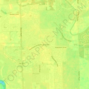
Name: Pecan Grove topographic map, elevation, terrain.
Location: Pecan Grove, Fort Bend County, Texas, 77496, United States (29.60607 -95.75162 29.64607 -95.71162)
Average elevation: 27 m
Minimum elevation: 10 m
Maximum elevation: 30 m
Make a donation
Other topographic maps
Click on a map to view its topography, its elevation and its terrain.
Sugar Land
United States > Texas > Fort Bend County
Sugar Land is located in northeast Fort Bend County, 20 miles (32 km) southwest of downtown Houston. It is bordered by Houston to the northeast, and by Stafford, Missouri City, and Meadows Place to the east. According to the United States Census Bureau, the city of Sugar Land has a total area of 34.0 square…
Average elevation: 24 m
Make a donation
Sugar Land
United States > Texas > Fort Bend County
Sugar Land is located in northeast Fort Bend County, 20 miles (32 km) southwest of downtown Houston. It is bordered by Houston to the northeast, and by Stafford, Missouri City, and Meadows Place to the east. According to the United States Census Bureau, the city of Sugar Land has a total area of 42.9 square…
Average elevation: 24 m
Brazos Bend State Park
United States > Texas > Fort Bend County > Alvin
Brazos Bend State Park occupies land bordering the Brazos River and includes within its boundaries low-lying areas left over from the River's previous meanderings. Pre-Columbian inhabitants included a series of Native American groups, most notably the Karankawa. The land passed through a variety of landowners'…
Average elevation: 17 m
Make a donation
Make a donation
Sienna (Brazos River) Park
United States > Texas > Fort Bend County > Missouri City
Average elevation: 20 m
Make a donation
Make a donation