
Thank you for supporting this site ❤️
Make a donation
Make a donation
Brownsville topographic map
Click on the map to display elevation.
Thank you for supporting this site ❤️
Make a donation
Make a donation
About this map
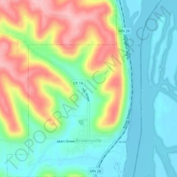
Name: Brownsville topographic map, elevation, terrain.
Location: Brownsville, Houston County, Minnesota, United States (43.68808 -91.29850 43.71729 -91.26967)
Average elevation: 247 m
Minimum elevation: 189 m
Maximum elevation: 354 m
Thank you for supporting this site ❤️
Make a donation
Make a donation
Other topographic maps
Click on a map to view its topography, its elevation and its terrain.
Thank you for supporting this site ❤️
Make a donation
Make a donation
Thank you for supporting this site ❤️
Make a donation
Make a donation
Thank you for supporting this site ❤️
Make a donation
Make a donation