
Ruiru topographic map
Click on the map to display elevation.
Ruiru
Ruiru is located about 20 kilometres (12 mi), by road, northeast of the central business district of Nairobi, the nation's capital city. The subcounty measures 292 km2 (113 sq mi) and is connected to Nairobi by both road and rail. The geographical co-ordinates of Ruiru are: 1°10'04.0"S, 36°58'24.0"E (Latitude: −1.167778; Longitude: 36.973333). The municipality sits at an average elevation of 1,565 metres (5,135 ft), above sea level.
About this map
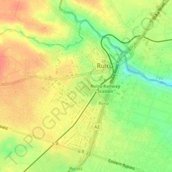
Name: Ruiru topographic map, elevation, terrain.
Location: Ruiru, Kiambu, Central Kenya, Kenya (-1.16498 36.93832 -1.13761 36.97252)
Average elevation: 1,529 m
Minimum elevation: 1,494 m
Maximum elevation: 1,552 m
Other topographic maps
Click on a map to view its topography, its elevation and its terrain.
Ruiru
Kenya > Kiambu > Ruiru > Biashara ward
Ruiru is about 20 kilometres (12 mi) by road northeast of the central business district of Nairobi, the nation's capital city. The sub-county measures 292 km2 (113 sq mi) and is connected to Nairobi by road and rail. The geographical coordinates of Ruiru are 1°10'04.0"S, 36°58'24.0" E (Latitude: −1.167778;…
Average elevation: 1,531 m