
Make a donation
Hawaiʻi County topographic map
Click on the map to display elevation.
Make a donation
About this map
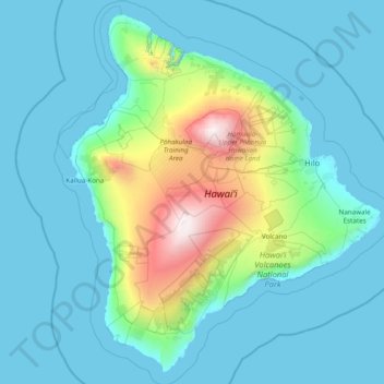
Name: Hawaiʻi County topographic map, elevation, terrain.
Location: Hawaiʻi County, Hawaii, United States (18.86546 -156.12000 20.32145 -154.75579)
Average elevation: 476 m
Minimum elevation: 0 m
Maximum elevation: 4,173 m
Make a donation
Other topographic maps
Click on a map to view its topography, its elevation and its terrain.
Piʻiholo
United States > Hawaii > Maui County
Piʻiholo is a mountain summit on the island of Maui in Hawaii. It is at 20°51′7″N 156°17′33″W / 20.85194°N 156.29250°W / 20.85194; -156.29250 and has an elevation of 689 meters (2,260 feet).
Average elevation: 587 m
Mauna Loa
United States > Hawaii > Hawaiʻi County
Mauna Loa is the largest subaerial and second largest overall volcano in the world (behind Tamu Massif), covering a land area of 5,271 km2 (2,035 sq mi) and spans a maximum width of 120 km (75 mi). Consisting of approximately 65,000 to 80,000 km3 (15,600 to 19,200 cu mi) of solid rock, it makes up more than…
Average elevation: 4,037 m
Make a donation