
Make a donation
Cultus Lake topographic map
Click on the map to display elevation.
Make a donation
About this map
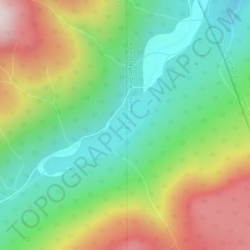
Name: Cultus Lake topographic map, elevation, terrain.
Average elevation: 1,033 m
Minimum elevation: 789 m
Maximum elevation: 1,432 m
Make a donation
Other topographic maps
Click on a map to view its topography, its elevation and its terrain.
Kamloops Lake
Canada > British Columbia > Thompson-Nicola Regional District > Area J (Copper Desert Country)
Average elevation: 975 m
Red Lake
Canada > British Columbia > Thompson-Nicola Regional District > Area J (Copper Desert Country)
Average elevation: 1,036 m
Savona
Canada > British Columbia > Thompson-Nicola Regional District > Area J (Copper Desert Country)
Average elevation: 480 m
Tunkwa Provincial Park
Canada > British Columbia > Thompson-Nicola Regional District > Area J (Copper Desert Country)
Average elevation: 1,226 m
Make a donation
Tunkwa Lake
Canada > British Columbia > Thompson-Nicola Regional District > Area J (Copper Desert Country)
Average elevation: 1,161 m
Lac Le Jeune Provincial Park
Canada > British Columbia > Thompson-Nicola Regional District > Area J (Copper Desert Country)
Average elevation: 1,308 m
Edith Lake
Canada > British Columbia > Thompson-Nicola Regional District > Area J (Copper Desert Country)
Average elevation: 1,054 m
Skeetchestn Indian Band
Canada > British Columbia > Thompson-Nicola Regional District > Area J (Copper Desert Country)
Average elevation: 1,091 m
Make a donation
Isobel Lake
Canada > British Columbia > Thompson-Nicola Regional District > Area J (Copper Desert Country)
Average elevation: 1,058 m
Greenstone Mountain
Canada > British Columbia > Thompson-Nicola Regional District > Area J (Copper Desert Country)
Average elevation: 1,624 m
Roper Hill
Canada > British Columbia > Thompson-Nicola Regional District > Area J (Copper Desert Country)
Average elevation: 486 m