
Make a donation
Lac Le Jeune Provincial Park topographic map
Click on the map to display elevation.
Make a donation
About this map
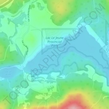
Name: Lac Le Jeune Provincial Park topographic map, elevation, terrain.
Average elevation: 1,308 m
Minimum elevation: 1,272 m
Maximum elevation: 1,428 m
Make a donation
Other topographic maps
Click on a map to view its topography, its elevation and its terrain.
Lac Le Jeune
Canada > British Columbia > Thompson-Nicola Regional District > Area J (Copper Desert Country)
Average elevation: 1,309 m
Savona
Canada > British Columbia > Thompson-Nicola Regional District > Area J (Copper Desert Country)
Average elevation: 480 m
Jacko Lake
Canada > British Columbia > Thompson-Nicola Regional District > Area J (Copper Desert Country)
Average elevation: 931 m
Snohoosh Lake
Canada > British Columbia > Thompson-Nicola Regional District > Area J (Copper Desert Country)
Average elevation: 1,000 m
Make a donation
Stake Lake
Canada > British Columbia > Thompson-Nicola Regional District > Area J (Copper Desert Country)
Average elevation: 1,351 m
Dominic Lake
Canada > British Columbia > Thompson-Nicola Regional District > Area J (Copper Desert Country)
Average elevation: 1,583 m
Cultus Lake
Canada > British Columbia > Thompson-Nicola Regional District > Area J (Copper Desert Country)
Average elevation: 1,033 m
McConnell Lake Provincial Park
Canada > British Columbia > Thompson-Nicola Regional District > Area J (Copper Desert Country)
Average elevation: 1,329 m
Make a donation
Fatox Lake
Canada > British Columbia > Thompson-Nicola Regional District > Area J (Copper Desert Country)
Average elevation: 1,173 m
Pat Lake
Canada > British Columbia > Thompson-Nicola Regional District > Area J (Copper Desert Country)
Average elevation: 667 m
Hoodoos
Canada > British Columbia > Thompson-Nicola Regional District > Area J (Copper Desert Country)
Average elevation: 469 m
Sparks Lake
Canada > British Columbia > Thompson-Nicola Regional District > Area J (Copper Desert Country)
Average elevation: 1,016 m
Make a donation
Porcupine Ridge
Canada > British Columbia > Thompson-Nicola Regional District > Area J (Copper Desert Country)
Average elevation: 1,798 m
Allen Meadows Lake
Canada > British Columbia > Thompson-Nicola Regional District > Area J (Copper Desert Country)
Average elevation: 1,214 m
Greenstone Mountain
Canada > British Columbia > Thompson-Nicola Regional District > Area J (Copper Desert Country)
Average elevation: 1,624 m
Roper Hill
Canada > British Columbia > Thompson-Nicola Regional District > Area J (Copper Desert Country)
Average elevation: 486 m
Make a donation