
Make a donation
Asperg topographic map
Click on the map to display elevation.
Make a donation
Asperg
The city (Stadt) of Asperg covers 5.38 square kilometers (2.08 sq mi) of the district of Ludwigsburg, in Baden-Württemberg, one of the 16 States of the Federal Republic of Germany. Asperg is physically located in the basin [de] of the Neckar river. Elevation above sea level in the municipal area ranges from a low of 241 meters (791 ft) Normalnull (NN) to a high of 352 meters (1,155 ft) NN.
Make a donation
About this map
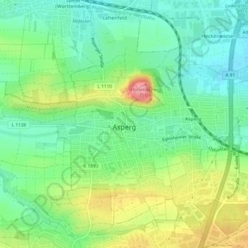
Name: Asperg topographic map, elevation, terrain.
Location: Asperg, Landkreis Ludwigsburg, Baden-Württemberg, 71679, Germany (48.89139 9.12281 48.92101 9.16301)
Average elevation: 280 m
Minimum elevation: 242 m
Maximum elevation: 348 m
Make a donation
Other topographic maps
Click on a map to view its topography, its elevation and its terrain.
Riet
Germany > Baden-Württemberg > Landkreis Ludwigsburg > Vaihingen an der Enz
Average elevation: 311 m
Ground Zero
Germany > Baden-Württemberg > Landkreis Ludwigsburg > Ludwigsburg
Average elevation: 304 m
Rielingshausen
Germany > Baden-Württemberg > Landkreis Ludwigsburg > Marbach am Neckar
Average elevation: 291 m
Nussdorf
Germany > Baden-Württemberg > Landkreis Ludwigsburg
The municipality (Gemeinde) of Eberdingen is located at the western extremity of the district of Ludwigsburg, in the German state of Baden-Württemberg, along its border with the districts of Böblingen and the Enz. Eberdingen is physically located in the basin of [de] the Neckar. Elevation above sea level in…
Average elevation: 321 m
Make a donation
Hohenhaslach
Germany > Baden-Württemberg > Landkreis Ludwigsburg > Sachsenheim
Average elevation: 281 m