
Make a donation
Nussdorf topographic map
Click on the map to display elevation.
Make a donation
Nussdorf
The municipality (Gemeinde) of Eberdingen is located at the western extremity of the district of Ludwigsburg, in the German state of Baden-Württemberg, along its border with the districts of Böblingen and the Enz. Eberdingen is physically located in the basin of [de] the Neckar. Elevation above sea level in the municipal area ranges from a high of 409 meters (1,342 ft) Normalnull (NN) to a low of 246 meters (807 ft) NN.
Make a donation
About this map
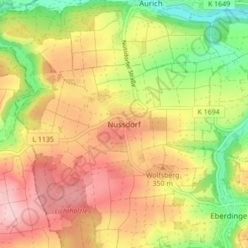
Name: Nussdorf topographic map, elevation, terrain.
Average elevation: 321 m
Minimum elevation: 219 m
Maximum elevation: 412 m
Make a donation
Other topographic maps
Click on a map to view its topography, its elevation and its terrain.
Eberdingen
Germany > Baden-Württemberg > Landkreis Ludwigsburg
The municipality (Gemeinde) of Eberdingen is located at the western extremity of the district of Ludwigsburg, in the German state of Baden-Württemberg, along its border with the districts of Böblingen and the Enz. Eberdingen is physically located in the basin of [de] the Neckar. Elevation above sea level in…
Average elevation: 332 m
Korntal-Münchingen
Germany > Baden-Württemberg > Landkreis Ludwigsburg
Korntal-Münchingen lies in the Strohgäu, at elevations between 285 and 405 meters, directly on the northwestern border of Stuttgart.
Average elevation: 320 m
Make a donation
Make a donation
Affalterbach
Germany > Baden-Württemberg > Landkreis Ludwigsburg
The municipality (Gemeinde) of Affalterbach is located at the eastern extremity of the district of Ludwigsburg, in the German state of Baden-Württemberg, along the border with the Rems-Murr district. Affalterbach lies on the Backnanger Bucht [de] in the basin of [de] the Neckar. Elevation above sea level in…
Average elevation: 285 m
Make a donation
Asperg
Germany > Baden-Württemberg > Landkreis Ludwigsburg
The city (Stadt) of Asperg covers 5.38 square kilometers (2.08 sq mi) of the district of Ludwigsburg, in Baden-Württemberg, one of the 16 States of the Federal Republic of Germany. Asperg is physically located in the basin [de] of the Neckar river. Elevation above sea level in the municipal area ranges from a…
Average elevation: 280 m
Ground Zero
Germany > Baden-Württemberg > Landkreis Ludwigsburg > Ludwigsburg
Average elevation: 304 m
Make a donation
Erdmannhausen
Germany > Baden-Württemberg > Landkreis Ludwigsburg
The municipality (Gemeinde) of Erdmannhausen is located at the eastern extremity of the district of Ludwigsburg, in the German state of Baden-Württemberg, along the border with the Rems-Murr district. Erdmannhausen is physically located in the basin of [de] the Neckar. Elevation above sea level in the…
Average elevation: 266 m
Make a donation
Vaihingen an der Enz
Germany > Baden-Württemberg > Landkreis Ludwigsburg
Vaihingen lies at an altitude of 200 to 450 metres at the end of the Strohgäus, on the western edge of the Neckarbecken in a valley widening of the Enz. The town centre lies on the east side of the river and is overlooked by the castle Kaltenstein.
Average elevation: 253 m
Kornwestheim
Germany > Baden-Württemberg > Landkreis Ludwigsburg > Kornwestheim
Average elevation: 299 m
Marbach am Neckar
Germany > Baden-Württemberg > Landkreis Ludwigsburg
The city (Stadt) of Marbach am Neckar covers 18.06 square kilometers (6.97 sq mi) of the district of Ludwigsburg in a total of four separate exclaves. Marbach is, according to government urban planning, part of the Stuttgart Metropolitan Region. Marbach's municipal areas are physically located in the basin of…
Average elevation: 251 m