
Make a donation
Malacca topographic map
Click on the map to display elevation.
Make a donation
Malacca
The state of Malacca covers an area of 1,775 km2 (685 sq mi). It is located on the southwestern coast of the Malay Peninsula opposite Sumatra, with the state of Negeri Sembilan to the north and west and Johor to the east. Malacca is situated roughly two-thirds of the way down the west coast, 149 km (93 mi) south of Kuala Lumpur and has a central position on the Strait of Malacca. With the exception of some of its small hills, Malacca is generally a lowland area with average elevation of less than 50 metres above sea level. While being relatively isolated from the Titiwangsa Mountains proper, which end near the border with Negeri Sembilan at the neighbouring towns of Pulau Sebang and Tampin, the hills are composed of Titiwangsa granite. The southernmost known Titiwangsa granite outcrop is known to be in Besar Island, off the coast of Jasin District. The 512-metre-tall Bukit Gapis, also known as Gunung Melaka, is the state's highest point.
Make a donation
About this map
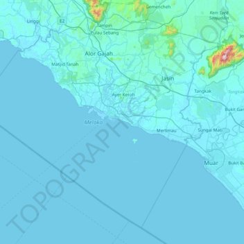
Name: Malacca topographic map, elevation, terrain.
Location: Malacca, Malaysia (1.83953 101.83280 2.49905 102.59438)
Average elevation: 26 m
Minimum elevation: -1 m
Maximum elevation: 1,186 m
Make a donation
Other topographic maps
Click on a map to view its topography, its elevation and its terrain.
Kuala Lumpur
Located in the centre of Selangor state, Kuala Lumpur was a territory of Selangor State Government. In 1974, Kuala Lumpur was split off from Selangor to form the first Federal Territory governed directly by the Malaysian federal government. Its location in the most developed state on the west coast of…
Average elevation: 127 m
Penang Island
Penang Island is irregularly shaped, with a hilly and mostly forested interior; its coastal plains are narrow, the most extensive of which is at the northeastern cape. With a height of 833 m (2,733 ft), Penang Hill, at the centre of the island, is the tallest point within Penang. From a small settlement at the…
Average elevation: 117 m
Make a donation
Pahang
The highest peak, Mount Tahan, reaches 2,187 m (7,175 ft) in elevation, which is also the highest point in the Peninsular Malaysia. The climate is temperate enough to have distinct temperature variations year round, and much of the highlands are covered with tropical rainforest. Pahang is home to Malaysia's…
Average elevation: 90 m
Kuala Terengganu
Malaysia > Terengganu > Kuala Terengganu
As a part of Terengganu, Kuala Terengganu has a tropical rainforest climate under the Köppen climate classification (Af) with constant temperature and high humidity. The amount of rainfall varies according to the monsoon season. It is generally fairly hot and humid all year round, averaging from 28 °C to 30…
Average elevation: 9 m
Cameron Highlands
Surveyed by the government geologist and explorer William Cameron in 1885, the outpost consists of three mukims (subdistricts), namely Ringlet, Tanah Rata and Ulu Telom. Its eight settlements are Ringlet, Tanah Rata (the administrative centre), Brinchang, the Bertam Valley, Kea Farm, Tringkap, Kampung Kuala…
Average elevation: 1,400 m
Make a donation
Make a donation
Make a donation
Make a donation
Make a donation
Make a donation
Tanah Rata
Tanah Rata is a town located in Cameron Highlands, Pahang, Malaysia. The name "tanah rata" means flat ground in Malay and it refers to the relatively flat area on which the town is located amidst this highland region. It has an elevation of 1,440 metres (4,720 ft).
Average elevation: 1,393 m
Make a donation
Seri Iskandar
Seri Iskandar (Jawi: سري إسكندر, Chinese: 斯里依斯干达) is a major town within the Perak Tengah District in the state of Perak, Malaysia. It is situated about 40 kilometers southwest of the city of Ipoh, the state capital. The town is at an average elevation of 29 meters above the sea level. The…
Average elevation: 29 m
Sibu
Sibu is located near the Rajang delta at the confluence of Rajang and Igan rivers. Peat swamp forests and alluvial plains are particularly prevalent in the Sibu Division. Sibu is located on a deep peat soil, which has caused problems in infrastructure development because buildings and roads slowly sink into…
Average elevation: 10 m
Make a donation
Mount Kinabalu
Mount Kinabalu (Malay: Gunung Kinabalu, Dusun: Gayo Ngaran or Nulu Nabalu) is the highest mountain in Borneo and Malaysia. With an elevation of 13,435 feet (4,095 m), it is third-highest peak of an island on Earth, and 20th most prominent mountain in the world by topographic prominence. The mountain is located…
Average elevation: 3,567 m
Make a donation
Make a donation
Make a donation
Make a donation
Genting Highlands
Genting Highlands is a hill station and a city located on the peak of Mount Ulu Kali in the Titiwangsa Mountains, central Peninsular Malaysia, at 1800 metres elevation. It is the second seat of Bentong District after Bentong. Located in the state of Pahang. It was established in 1965 by the late Malaysian…
Average elevation: 1,141 m
Make a donation
Make a donation
Tanah Rata
Tanah Rata is a town located in Cameron Highlands, Pahang, Malaysia. The name "tanah rata" means flat ground in Malay and it refers to the relatively flat area on which the town is located amidst this highland region. It has an elevation of 1,440 metres (4,720 ft).
Average elevation: 1,393 m
Make a donation
Make a donation
Make a donation
Make a donation
Make a donation
Make a donation
Make a donation
Make a donation
Sungai Haji Dorani
Malaysia > Selangor > Kampung Sungai Haji Dorani > Kampung Nelayan Sungai Haji Durani
Average elevation: 3 m
Make a donation
Make a donation