
Thank you for supporting this site ❤️
Make a donation
Make a donation
Kangar topographic map
Click on the map to display elevation.
Thank you for supporting this site ❤️
Make a donation
Make a donation
About this map
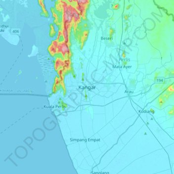
Name: Kangar topographic map, elevation, terrain.
Location: Kangar, Perlis, 01000, Malaysia (6.27893 100.03448 6.59893 100.35448)
Average elevation: 28 m
Minimum elevation: -4 m
Maximum elevation: 485 m
Thank you for supporting this site ❤️
Make a donation
Make a donation
Other topographic maps
Click on a map to view its topography, its elevation and its terrain.