
Saas-Fee topographic map
Interactive map
Click on the map to display elevation.
About this map
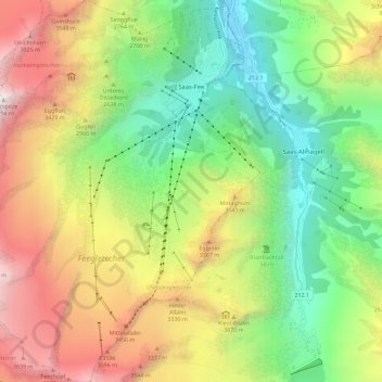
Name: Saas-Fee topographic map, elevation, terrain.
Location: Saas-Fee, Visp, Valais/Wallis, 3906, Zwitserland (46.04609 7.85721 46.12524 7.94542)
Average elevation: 2,673 m
Minimum elevation: 1,560 m
Maximum elevation: 4,272 m
Other topographic maps
Click on a map to view its topography, its elevation and its terrain.
Zermatt
Zwitserland > Valais/Wallis > Visp
Zermatt, Visp, Valais/Wallis, 3920, Zwitserland
Average elevation: 2,921 m
Grächen
Zwitserland > Valais/Wallis > Visp
Grächen, Visp, Valais/Wallis, 3925, Zwitserland
Average elevation: 1,757 m
Dufourspitze
Zwitserland > Valais/Wallis > Visp > Zermatt
Dufourspitze, Zermatt, Visp, Valais/Wallis, 3920, Zwitserland
Average elevation: 4,033 m
Zermatt
Zwitserland > Valais/Wallis > Visp > Zermatt > Zermatt
Zermatt, Visp, Valais/Wallis, 3920, Zwitserland
Average elevation: 2,469 m