
Grächen topographic map
Interactive map
Click on the map to display elevation.
About this map
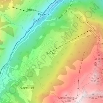
Name: Grächen topographic map, elevation, terrain.
Location: Grächen, Visp, Valais/Wallis, 3925, Zwitserland (46.17343 7.81783 46.22015 7.87375)
Average elevation: 1,757 m
Minimum elevation: 834 m
Maximum elevation: 3,017 m
Grächen telt 1.396 inwoners en is gedeeltelijk autovrij. Het dorp ligt op een plateau in het Zwitserse Mattertal op een hoogte van ongeveer 1600 meter. Vanuit het dorp is een fraai panorama te zien van onder andere de Weisshorn en de Bietschhorn. Bij helder weer is de Matterhorn, een van de hoogste bergen van Zwitserland, zichtbaar. Het van oorsprong agrarische dorp richt zich tegenwoordig op toerisme en is vooral bij families met kinderen in trek.
Other topographic maps
Click on a map to view its topography, its elevation and its terrain.
Zermatt
Zwitserland > Valais/Wallis > Visp
Zermatt, Visp, Valais/Wallis, 3920, Zwitserland
Average elevation: 2,921 m
Dufourspitze
Zwitserland > Valais/Wallis > Visp > Zermatt
Dufourspitze, Zermatt, Visp, Valais/Wallis, 3920, Zwitserland
Average elevation: 4,033 m
Saas-Fee
Zwitserland > Valais/Wallis > Visp
Saas-Fee, Visp, Valais/Wallis, 3906, Zwitserland
Average elevation: 2,673 m
Zermatt
Zwitserland > Valais/Wallis > Visp > Zermatt > Zermatt
Zermatt, Visp, Valais/Wallis, 3920, Zwitserland
Average elevation: 2,469 m