
Thank you for supporting this site ❤️
Make a donation
Make a donation
Falcon Heights topographic map
Click on the map to display elevation.
Thank you for supporting this site ❤️
Make a donation
Make a donation
About this map
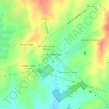
Name: Falcon Heights topographic map, elevation, terrain.
Location: Falcon Heights, Starr County, Texas, 78585, United States (26.53881 -99.14280 26.57881 -99.10280)
Average elevation: 93 m
Minimum elevation: 67 m
Maximum elevation: 124 m
Thank you for supporting this site ❤️
Make a donation
Make a donation
Other topographic maps
Click on a map to view its topography, its elevation and its terrain.
Lower Rio Grande Valley National Wildlife Refuge
United States > Texas > Starr County > Rio Grande City
Average elevation: 50 m
Thank you for supporting this site ❤️
Make a donation
Make a donation
Thank you for supporting this site ❤️
Make a donation
Make a donation