
Preston topographic map
Click on the map to display elevation.
About this map
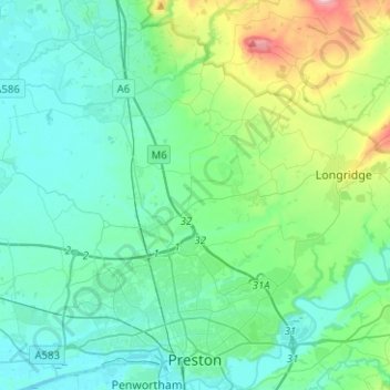
Name: Preston topographic map, elevation, terrain.
Location: Preston, Lancashire, England, United Kingdom (53.74801 -2.82600 53.89615 -2.59544)
Average elevation: 58 m
Minimum elevation: 1 m
Maximum elevation: 308 m
Other topographic maps
Click on a map to view its topography, its elevation and its terrain.
Billington and Langho
United Kingdom > England > Lancashire > Ribble Valley > Brockhall Village
Average elevation: 58 m
Old Langho
United Kingdom > England > Lancashire > Ribble Valley > Brockhall Village
Average elevation: 74 m
Accrington
United Kingdom > England > Lancashire > Hyndburn
Geographical coordinates: 53° 46' 0" North, 2° 21' 0" West. Height above sea level: there is a spot height outside the Market Hall which is 133.5 metres (438 ft) the benchmark on the side of the neighbouring Town Hall is 441.10 feet (134.45 m). The highest height in the town is 320 metres (1,050 ft) which is…
Average elevation: 199 m
Bacup
United Kingdom > England > Lancashire > Borough of Rossendale
The geology and topography of the village lent itself to urbanisation and domestic industries; primitive weavers' cottages, coal pits and stone quarries were propelled by Bacup's natural supply of water power in the Early Modern period. The adoption of the factory system, which developed into the Industrial…
Average elevation: 337 m
Haslingden Grane
United Kingdom > England > Lancashire > Borough of Rossendale > Haslingden
Average elevation: 287 m
Colne Water
United Kingdom > England > Lancashire > Borough of Pendle > Laneshaw Bridge
Average elevation: 202 m
Silverdale Green
United Kingdom > England > Lancashire > Lancaster > Silverdale
Average elevation: 24 m
Haslingden Grane
United Kingdom > England > Lancashire > Borough of Rossendale
Average elevation: 305 m
Larbreck
United Kingdom > England > Lancashire > Borough of Fylde > Little Eccleston
Average elevation: 12 m
Walton Summit
United Kingdom > England > Lancashire > South Ribble > Bamber Bridge
Average elevation: 67 m
Irwell Springs
United Kingdom > England > Lancashire > Borough of Rossendale > Weir
Average elevation: 365 m
Clowbridge
United Kingdom > England > Lancashire > Borough of Rossendale > Habergham Eaves
Average elevation: 319 m
Brungerley Park
United Kingdom > England > Lancashire > Ribble Valley > Clitheroe > Waddington
Average elevation: 77 m
Whitewell Bottom
United Kingdom > England > Lancashire > Borough of Rossendale > Sagar Holme
Average elevation: 281 m
Fold Head
United Kingdom > England > Lancashire > Borough of Rossendale > Healey
Average elevation: 294 m
Trough Gate
United Kingdom > England > Lancashire > Borough of Rossendale > Britannia
Average elevation: 341 m
Forest Holme
United Kingdom > England > Lancashire > Borough of Rossendale > Water
Average elevation: 318 m
Scarth Hill
United Kingdom > England > Lancashire > West Lancashire > Ormskirk
Average elevation: 58 m