
Thank you for supporting this site ❤️
Make a donation
Make a donation
Hesketh Lane topographic map
Click on the map to display elevation.
Thank you for supporting this site ❤️
Make a donation
Make a donation
About this map
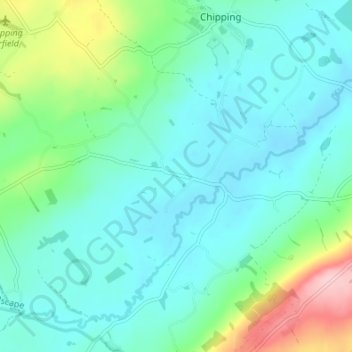
Name: Hesketh Lane topographic map, elevation, terrain.
Average elevation: 131 m
Minimum elevation: 90 m
Maximum elevation: 278 m
Thank you for supporting this site ❤️
Make a donation
Make a donation
Other topographic maps
Click on a map to view its topography, its elevation and its terrain.
Billington and Langho
United Kingdom > England > Lancashire > Ribble Valley > Brockhall Village
Average elevation: 58 m
Thank you for supporting this site ❤️
Make a donation
Make a donation
Osbaldeston
United Kingdom > England > Lancashire > Ribble Valley > Osbaldeston
Average elevation: 74 m
Waddington
United Kingdom > England > Lancashire > Ribble Valley > Waddington
Average elevation: 164 m
Thank you for supporting this site ❤️
Make a donation
Make a donation
Brungerley Park
United Kingdom > England > Lancashire > Ribble Valley > Clitheroe > Waddington
Average elevation: 77 m
Thank you for supporting this site ❤️
Make a donation
Make a donation
Thank you for supporting this site ❤️
Make a donation
Make a donation
Thank you for supporting this site ❤️
Make a donation
Make a donation
Waddington
United Kingdom > England > Lancashire > Ribble Valley > Waddington
Average elevation: 164 m
Thank you for supporting this site ❤️
Make a donation
Make a donation