
Thank you for supporting this site ❤️
Make a donation
Make a donation
Geneva topographic map
Click on the map to display elevation.
Thank you for supporting this site ❤️
Make a donation
Make a donation
About this map
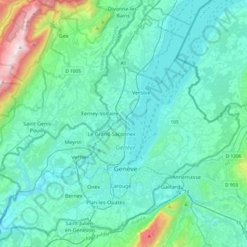
Name: Geneva topographic map, elevation, terrain.
Location: Geneva, Switzerland (46.12855 5.95591 46.36457 6.31029)
Average elevation: 522 m
Minimum elevation: 342 m
Maximum elevation: 1,678 m
Thank you for supporting this site ❤️
Make a donation
Make a donation
Other topographic maps
Click on a map to view its topography, its elevation and its terrain.
Kiental
Switzerland > Bern > Frutigen-Niedersimmental administrative district > Reichenbach im Kandertal
Average elevation: 1,363 m
Thank you for supporting this site ❤️
Make a donation
Make a donation
Brienz
Switzerland > Bern > Interlaken-Oberhasli administrative district > Brienz (BE)
Average elevation: 810 m
Under Tanneboumgrabe
Switzerland > Bern > Interlaken-Oberhasli administrative district > Unterseen > Tanneboum
Average elevation: 862 m
Thank you for supporting this site ❤️
Make a donation
Make a donation