
Thank you for supporting this site ❤️
Make a donation
Make a donation
Wengen topographic map
Click on the map to display elevation.
Thank you for supporting this site ❤️
Make a donation
Make a donation
About this map
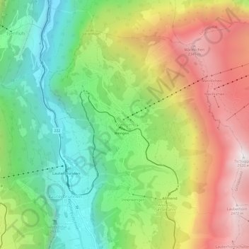
Name: Wengen topographic map, elevation, terrain.
Average elevation: 1,450 m
Minimum elevation: 664 m
Maximum elevation: 2,496 m
Thank you for supporting this site ❤️
Make a donation
Make a donation
Other topographic maps
Click on a map to view its topography, its elevation and its terrain.
Under Tanneboumgrabe
Switzerland > Bern > Interlaken-Oberhasli administrative district > Unterseen > Tanneboum
Average elevation: 862 m