
Marz topographic map
Interactive map
Click on the map to display elevation.
About this map
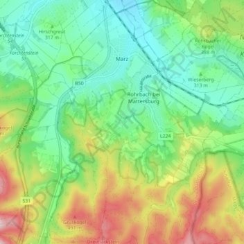
Name: Marz topographic map, elevation, terrain.
Location: Marz, Bezirk Mattersburg, Burgenland, 7221, Österreich (47.67471 16.36352 47.73308 16.44234)
Average elevation: 339 m
Minimum elevation: 227 m
Maximum elevation: 550 m
Das Hügelgräberfeld auf der „Leberweide“, einer Anhöhe südlich des Ortes, stammt aus der Eisenzeit. Ein großes Tongefäß, das auf der Schulter zwei plastisch modellierte erhobene Hände trägt, befindet sich im Naturhistorischen Museum in Wien.
Other topographic maps
Click on a map to view its topography, its elevation and its terrain.
Mattersburg
Österreich > Burgenland > Bezirk Mattersburg
Mattersburg, Bezirk Mattersburg, Burgenland, 7210, Österreich
Average elevation: 332 m
Mattersburg
Österreich > Burgenland > Bezirk Mattersburg > Mattersburg > Mattersburg
Mattersburg, Bezirk Mattersburg, Burgenland, 7210, Österreich
Average elevation: 284 m
Forchtenstein
Österreich > Burgenland > Bezirk Mattersburg
Forchtenstein, Bezirk Mattersburg, Burgenland, 7212, Österreich
Average elevation: 432 m