
Mattersburg topographic map
Interactive map
Click on the map to display elevation.
About this map
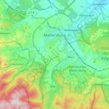
Name: Mattersburg topographic map, elevation, terrain.
Location: Mattersburg, Bezirk Mattersburg, Burgenland, 7210, Österreich (47.67852 16.30904 47.76329 16.44012)
Average elevation: 332 m
Minimum elevation: 195 m
Maximum elevation: 674 m
Vor Christi Geburt war das Gebiet Teil des keltischen Königreiches Noricum und gehörte zur Umgebung der keltischen Höhensiedlung Burg auf dem Schwarzenbacher Burgberg.
Other topographic maps
Click on a map to view its topography, its elevation and its terrain.
Marz
Österreich > Burgenland > Bezirk Mattersburg
Marz, Bezirk Mattersburg, Burgenland, 7221, Österreich
Average elevation: 339 m
Mattersburg
Österreich > Burgenland > Bezirk Mattersburg > Mattersburg > Mattersburg
Mattersburg, Bezirk Mattersburg, Burgenland, 7210, Österreich
Average elevation: 284 m
Forchtenstein
Österreich > Burgenland > Bezirk Mattersburg
Forchtenstein, Bezirk Mattersburg, Burgenland, 7212, Österreich
Average elevation: 432 m