
Make a donation
Plaza de Roma topographic map
Click on the map to display elevation.
Make a donation
Plaza de Roma
In 1901, with the start of American rule, the plaza was renamed Plaza McKinley, after U.S. President William McKinley, who authorized the colonization of the Philippines by the United States. The plaza was given its current name in 1961, following the elevation of Rufino Santos to the College of Cardinals of the Catholic Church as the first Filipino cardinal. In recognition of this, the city of Rome reciprocated by renaming one of its squares Piazzale Manila.
Make a donation
About this map
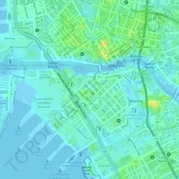
Name: Plaza de Roma topographic map, elevation, terrain.
Average elevation: 7 m
Minimum elevation: -3 m
Maximum elevation: 26 m
Make a donation
Other topographic maps
Click on a map to view its topography, its elevation and its terrain.
Manila
Almost all of Manila sits on top of centuries of prehistoric alluvial deposits built by the waters of the Pasig River and on some land reclaimed from Manila Bay. Manila's land has been altered substantially by human intervention, with considerable land reclamation along the waterfronts since the American…
Average elevation: 6 m
Make a donation
Make a donation
Make a donation
Santa Mesa
The topography of the area is relatively flat as some of the natural variations in elevations have been evened out due to urbanization.
Average elevation: 9 m
Make a donation
Make a donation
Make a donation
Make a donation
Make a donation
Make a donation
Make a donation
Make a donation
Make a donation
Make a donation
Make a donation
Make a donation
Make a donation
Make a donation
Make a donation
Make a donation
Make a donation
Make a donation
Santa Mesa
The topography of the area is relatively flat as some of the natural variations in elevations have been evened out due to urbanization.
Average elevation: 9 m