
Thank you for supporting this site ❤️
Make a donation
Make a donation
Maxwell topographic map
Click on the map to display elevation.
Thank you for supporting this site ❤️
Make a donation
Make a donation
About this map
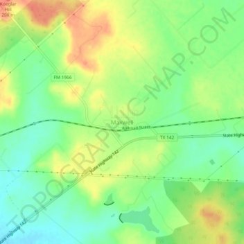
Name: Maxwell topographic map, elevation, terrain.
Location: Maxwell, Caldwell County, Texas, 78656, United States (29.86190 -97.81564 29.90190 -97.77564)
Average elevation: 185 m
Minimum elevation: 163 m
Maximum elevation: 209 m
Thank you for supporting this site ❤️
Make a donation
Make a donation
Other topographic maps
Click on a map to view its topography, its elevation and its terrain.
Thank you for supporting this site ❤️
Make a donation
Make a donation
Lockhart State Park
United States > Texas > Caldwell County > Lockhart
The park features roughly four miles of designated trails that cover a wide range of environments. In addition to multiple short, shade covered trails along the creek in a riparian zone, a network of natural trails traversing multiple hillsides and ravines is located on the backside of the park. A moderate…
Average elevation: 165 m