
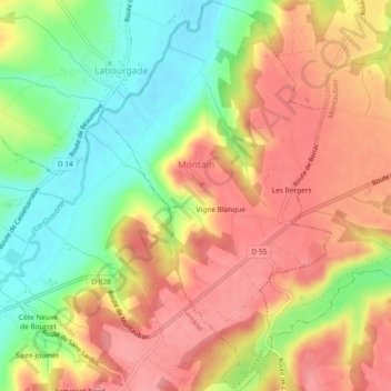
Montaïn topographic map
Interactive map
Click on the map to display elevation.
About this map
Name: Montaïn topographic map, elevation, terrain.
Average elevation: 135 m
Minimum elevation: 83 m
Maximum elevation: 177 m
La superficie de la commune est de 404 hectares ; son altitude varie de 86 à 174 mètres.
Other topographic maps
Click on a map to view its topography, its elevation and its terrain.
Lauzerte
France > Occitanie > Tarn-et-Garonne
Lauzerte, Castelsarrasin, Tarn-et-Garonne, Occitanie, France métropolitaine, 82110, France
Average elevation: 167 m
Moissac
France > Occitanie > Tarn-et-Garonne
Moissac, Castelsarrasin, Tarn-et-Garonne, Occitanie, France métropolitaine, 82200, France
Average elevation: 113 m