
Lauzerte topographic map
Interactive map
Click on the map to display elevation.
About this map
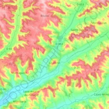
Name: Lauzerte topographic map, elevation, terrain.
Average elevation: 167 m
Minimum elevation: 88 m
Maximum elevation: 260 m
Other topographic maps
Click on a map to view its topography, its elevation and its terrain.
Montaïn
France > Occitanie > Tarn-et-Garonne
Montaïn, Castelsarrasin, Tarn-et-Garonne, Occitanie, France métropolitaine, 82100, France
Average elevation: 135 m
Moissac
France > Occitanie > Tarn-et-Garonne
Moissac, Castelsarrasin, Tarn-et-Garonne, Occitanie, France métropolitaine, 82200, France
Average elevation: 113 m