
Mid-Western Development Region topographic map
Interactive map
Click on the map to display elevation.
About this map
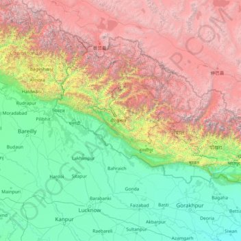
Name: Mid-Western Development Region topographic map, elevation, terrain.
Location: Mid-Western Development Region, Karnali Pradesh, Nepal (26.07861 79.12901 31.19861 84.24901)
Average elevation: 2,076 m
Minimum elevation: 57 m
Maximum elevation: 7,878 m
Other topographic maps
Click on a map to view its topography, its elevation and its terrain.
Chapre
Nepal > Mid-Western Development Region > Chapre
Chapre, Surkhet, Bheri, Mid-Western Development Region, Nepal
Average elevation: 1,034 m
Mid-Western Development Region
Nepal > Mid-Western Development Region
Mid-Western Development Region, Nepal
Average elevation: 2,353 m
Ghaghara River
Nepal > Mid-Western Development Region
Ghaghara River, Dailekh, Bheri, Mid-Western Development Region, 271833, Nepal
Average elevation: 1,522 m