
Mid-Western Development Region topographic map
Interactive map
Click on the map to display elevation.
About this map
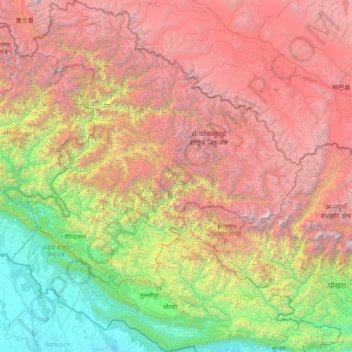
Name: Mid-Western Development Region topographic map, elevation, terrain.
Location: Mid-Western Development Region, Nepal (27.67644 80.98100 30.44695 83.67995)
Average elevation: 2,353 m
Minimum elevation: 115 m
Maximum elevation: 7,470 m
Other topographic maps
Click on a map to view its topography, its elevation and its terrain.
Mid-Western Development Region
Nepal > Mid-Western Development Region
Mid-Western Development Region, Karnali Pradesh, Nepal
Average elevation: 2,076 m
Chapre
Nepal > Mid-Western Development Region > Chapre
Chapre, Surkhet, Bheri, Mid-Western Development Region, Nepal
Average elevation: 1,034 m
Ghaghara River
Nepal > Mid-Western Development Region
Ghaghara River, Dailekh, Bheri, Mid-Western Development Region, 271833, Nepal
Average elevation: 1,522 m