
Thank you for supporting this site ❤️
Make a donation
Make a donation
Laguna Madre topographic map
Click on the map to display elevation.
Thank you for supporting this site ❤️
Make a donation
Make a donation
About this map
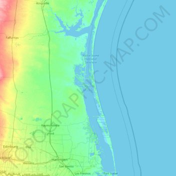
Name: Laguna Madre topographic map, elevation, terrain.
Location: Laguna Madre, Kenedy County, Texas, USA (26.05054 -97.79910 27.54125 -97.16250)
Average elevation: 10 m
Minimum elevation: -2 m
Maximum elevation: 89 m
Thank you for supporting this site ❤️
Make a donation
Make a donation
Other topographic maps
Click on a map to view its topography, its elevation and its terrain.