Geolocate

Palāmu topographic map

Click on the map to display elevation.

About this map

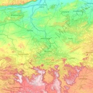
Name: Palāmu topographic map, elevation, terrain.

Location: Palāmu, Palamu District, Jharkhand, India (23.21667 83.38333 24.61667 84.78333)

Average elevation: 448 m

Minimum elevation: 120 m

Maximum elevation: 1,217 m

Other topographic maps

Click on a map to view its topography, its elevation and its terrain.

Pathara

India > Jharkhand > Borio > Pathra

Average elevation: 86 m

Mandar

India > Jharkhand

Average elevation: 684 m

Bundu

India > Jharkhand

Average elevation: 384 m

Dumka

India > Jharkhand

Average elevation: 160 m

Mandu

India > Jharkhand

Average elevation: 455 m

Chainpur

India > Jharkhand

Average elevation: 288 m

Ramna

India > Jharkhand

Average elevation: 272 m

South Karo River

India > Jharkhand > Tonto

Average elevation: 343 m

Mande

India > Jharkhand > Taljhari

Average elevation: 112 m

Meral (Pipra Kalan)

India > Jharkhand

Average elevation: 252 m

Maheshpur

India > Jharkhand

Average elevation: 68 m

Alampur

India > Jharkhand > Rajmahal

Average elevation: 29 m

Gumia

India > Jharkhand

Average elevation: 374 m

Garu

India > Jharkhand

Average elevation: 587 m

Giridih

India > Jharkhand > Giridih

Giridih is located at 24°11′N 86°18′E / 24.18°N 86.3°E / 24.18; 86.3. It has an average elevation of 289 metres (948 ft). Śrī Sammed Shikharji also known as the Parasnath Hills, located in Giridih district is the highest mountain peak in Jharkhand. It is a conical granite peak located 4,477…

Average elevation: 292 m

Bishrampur

India > Jharkhand

Average elevation: 207 m

Pipra

India > Jharkhand

Average elevation: 213 m

Chhatarpur

India > Jharkhand

Average elevation: 281 m

Tirla

India > Jharkhand > Erki(Tamar II)

Average elevation: 603 m

Telo

India > Jharkhand > Borio

Average elevation: 80 m

Sagma

India > Jharkhand

Average elevation: 292 m

Hussainabad

India > Jharkhand

Average elevation: 191 m

Garhwa

India > Jharkhand

Average elevation: 229 m

Barkagaon

India > Jharkhand

Average elevation: 491 m

Moti Jharna

India > Jharkhand > Taljhari > Maharajpur

Average elevation: 92 m

Dharampur

India > Jharkhand > Rajmahal

Average elevation: 28 m

Marwa

India > Jharkhand > Borio

Average elevation: 111 m

Deoghar

India > Jharkhand

Average elevation: 258 m

Gumla District

India > Jharkhand

Average elevation: 696 m

Kander

India > Jharkhand > Erki(Tamar II)

Average elevation: 583 m

Kharaundhi

India > Jharkhand

Average elevation: 214 m

Lewa

India > Jharkhand > Borio

Average elevation: 172 m

Ajodhya

India > Jharkhand > Taljhari

Average elevation: 42 m

Ganga Parshad

India > Jharkhand > Sahibganj (block) > Sahibganj

Average elevation: 74 m

Baghmara-Cum-Katras

India > Jharkhand > Dhanbad

Average elevation: 227 m

Kuru

India > Jharkhand > Kuru

Average elevation: 646 m

Nawadih

India > Jharkhand

Average elevation: 306 m

Rock Garden

India > Jharkhand > Kanke > Ranchi

Average elevation: 644 m

Usri Nadi

India > Jharkhand > Giridih

Average elevation: 273 m

Sakri

India > Jharkhand > Gawan

Average elevation: 228 m

Ghaghra

India > Jharkhand

Average elevation: 750 m

Sarath

India > Jharkhand

Average elevation: 211 m

Manikpur

India > Jharkhand > Rajmahal

Average elevation: 32 m

Jamtara

India > Jharkhand

Average elevation: 172 m

Gumla

India > Jharkhand

Average elevation: 647 m

Latehar

India > Jharkhand

Average elevation: 452 m

Kolebira

India > Jharkhand > Kolebira

Average elevation: 529 m

Sahibganj

India > Jharkhand > Sahibganj

Average elevation: 65 m

Kharsawan

India > Jharkhand

Average elevation: 243 m

Simra

India > Jharkhand > Borio > Borio

Average elevation: 104 m

Ghatshila

India > Jharkhand > Ghatshila

Average elevation: 175 m

Dimna Lake

India > Jharkhand > Boram > Pagda

Average elevation: 212 m

Kuchai

India > Jharkhand > Kuchai

Average elevation: 327 m

Kanchi

India > Jharkhand > Sonahatu

Average elevation: 453 m

North Koel River

India > Jharkhand > Garu > Garu

Average elevation: 515 m

Giridih

India > Jharkhand

Average elevation: 295 m

Rajmahal

India > Jharkhand > Rajmahal

Average elevation: 46 m

Khunti

India > Jharkhand

Average elevation: 562 m

Kodarma

India > Jharkhand

Average elevation: 285 m

Lohardaga

India > Jharkhand

Average elevation: 661 m

Pakaur

India > Jharkhand

Average elevation: 38 m

Ramgarh

India > Jharkhand

Average elevation: 426 m

Saraikela

India > Jharkhand

Average elevation: 206 m

Katamdag

India > Jharkhand > Katamdag

Average elevation: 600 m

Topchanchi

India > Jharkhand > Dhanbad

Average elevation: 311 m

Seraikela Kharsawan

India > Jharkhand

Average elevation: 252 m

Kanha Chatti

India > Jharkhand

Average elevation: 359 m