Basque Country topographic map
Click on the map to display elevation.
Basque Country
The Basque Country region is dominated by a warm, humid and wet oceanic climate. The coastal area is part of Green Spain and by extension, the climate is similar for Bayonne and Biarritz as well. Inland areas in Navarre and the southern regions of the autonomous community are transitional, with continental Mediterranean climate, with somewhat wider temperature swings between seasons. The list only sources locations in Spain, but Bayonne/Biarritz have a very similar climate to nearby Hondarribia on the Spanish side of the border. The values do not apply to San Sebastián, since its weather station is at a higher elevation than the urban core, where temperatures are higher year-round and similar to those in Bilbao and Hondarribia.
About this map
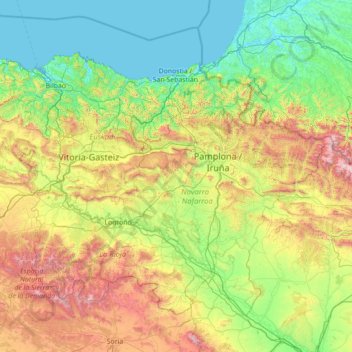
Name: Basque Country topographic map, elevation, terrain.
Location: Basque Country, Spain (41.90989 -3.45091 43.54743 -0.65272)
Average elevation: 560 m
Minimum elevation: -2 m
Maximum elevation: 2,626 m
Other topographic maps
Click on a map to view its topography, its elevation and its terrain.

Napal
Spain > Navarre > Zangozerria / Comarca de Sangüesa > Romanzado/Erromantzatua
Average elevation: 710 m
Muleta
Spain > Aragon > Matarraña / Matarranya > Valderrobres / Vall de Roures
Average elevation: 1,131 m

Piedra del Águila
Spain > Andalusia > Comarca de Huéscar > Puebla de Don Fadrique
Average elevation: 1,295 m
Soil
Spain > Autonomous Community of the Basque Country > Montaña Alavesa/Arabako Mendialdea
Average elevation: 898 m
Parque Alcalde José Sánchez
Spain > Campo de Cartagena y Mar Menor > San Pedro del Pinatar > Los Peñascos
Average elevation: 7 m
Cerro de Fabián
Spain > Andalusia > Sierra de Cádiz > Villaluenga del Rosario
Average elevation: 736 m

Cerro Teresa
Spain > Castile-La Mancha > Mesa de Ocaña > Santa Cruz de la Zarza
Average elevation: 774 m