
Make a donation
Lorraine topographic map
Click on the map to display elevation.
Make a donation
About this map
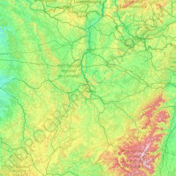
Name: Lorraine topographic map, elevation, terrain.
Location: Lorraine, Metropolitan France, France (47.81369 4.88846 49.61693 7.63882)
Average elevation: 320 m
Minimum elevation: 105 m
Maximum elevation: 1,331 m
Make a donation
Other topographic maps
Click on a map to view its topography, its elevation and its terrain.
Val Thorens
France > Auvergne-Rhône-Alpes > Savoy
Val Thorens ([val tɔʁɑ̃]) is a ski town in the Tarentaise Valley in the French Alps at an altitude of 2,300 m (7,500 ft). It is located in the commune of Saint-Martin-de-Belleville in the Savoie department. The resort forms part of the Les Trois Vallées ski area which, with over 600 km of slopes, is one…
Average elevation: 2,516 m
La Bérarde
France > Auvergne-Rhône-Alpes > Isère > Saint-Christophe-en-Oisans
Average elevation: 2,307 m
Rivière de Contournement et de Pratiques en Eaux Vives (RICPEV) de l'Île Balzac
France > Centre-Val de Loire > Indre-et-Loire > Tours
Average elevation: 56 m
Make a donation
Cirque de consolation
France > Bourgogne – Franche-Comté > Doubs > Consolation-Maisonnettes
Average elevation: 732 m
Make a donation
Le Blanc Chat
France > Auvergne-Rhône-Alpes > Upper Savoy > Épagny Metz-Tessy
Average elevation: 487 m
Make a donation
Le Génetoux
France > Centre-Loire Valley > Indre > Saint-Marcel > Le Génetoux
Average elevation: 151 m
Make a donation
Paris
Paris in its early history had only the rivers Seine and Bièvre for water. From 1809, the Canal de l'Ourcq provided Paris with water from less-polluted rivers to the north-east of the capital. From 1857, the civil engineer Eugène Belgrand, under Napoleon III, oversaw the construction of a series of new…
Average elevation: 75 m
Les Ansaults
France > Centre-Loire Valley > Indre-et-Loire > Artannes-sur-Indre > Les Ansaults
Average elevation: 73 m
La Grave de Peille
France > Provence-Alpes-Côte d'Azur > Maritime Alps > Peille > La Grave de Peille
Average elevation: 400 m
Make a donation
Albaron
France > Provence-Alpes-Côte d'Azur > Bouches-du-Rhône > Arles > Albaron
Average elevation: 1 m
Les Mignotières
France > Auvergne-Rhône-Alpes > Métropole de Lyon > Genay > Les Mignotières
Average elevation: 230 m
Vautredeix
France > New Aquitaine > Creuse > Saint-Silvain-sous-Toulx > Vautredeix
Average elevation: 448 m
Make a donation
Ruisseau de l'Escourt
France > Auvergne-Rhône-Alpes > Ardèche > Malarce-sur-la-Thines > Fontoux
Average elevation: 313 m